National Public Lands Day, September 23rd

For 30 years, National Public Lands Day has mobilized volunteers of all ages to engage in a celebration of service and stewardship of America’s public lands. The event is the largest single-day national volunteer effort to preserve, restore, improve and enjoy America’s public lands.

Fairfax County Park Authority invites you to be a part of their celebration of National Public Lands Day by taking part in any of a wide selection of service activities to protect the natural, cultural and recreational resources of our treasured park system!

Check out their list of service opportunities by location that day.

Science in Your Watershed

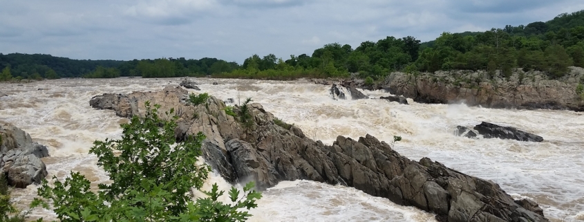
Feature photo: The Mighty Potomac on June 2, 2018

Article, photo and images provided by FMN Stephen Tzikas

A watershed is a common geographic area that drains all streams and rivers into a common outlet, like a bay.  The Northern Virginia Soil and Water Conservation District has a macroinvertebrate stream monitoring program that helps protect our watersheds:

https://www.fairfaxcounty.gov/soil-water-conservation/volunteer-stream-monitoring

Getting to know your watershed is like getting to know your neighborhood.  Our local Potomac Watershed is part of the Chesapeake Watershed, which is part of the Mid-Atlantic Watershed, and which is part of the Eastern Watershed.  A principal river of a basin is a river that drains directly into the ocean.  Our Atlantic Seaboard Basin includes the Hudson River, Delaware River, Susquehanna River, our local Potomac River, and the Savannah River.  Your watershed’s information can be found at this USGS website which contains many USGS links:

https://water.usgs.gov/wsc/map_index.html

You can visit the Environmental Protection Agency (EPA) website, type in your zip code, and get a local map of your watershed: https://www.epa.gov/waterdata/hows-my-waterwayFor example, my Reston home location is part of the local Difficult Run watershed.

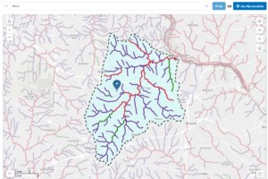
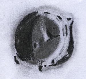
Illustration by author:  Local Watershed Generated by the EPA website per input of the 20191 zip code. Notice the drainage pattern. Depending on a location’s geology, drainage patterns can be dendritic, trellis-like, rectangular, or radial.

The website provides physical, chemical and biological water quality factors from its monitoring locations.  In Fairfax County, drinking water comes from two major sources: the Occoquan Reservoir and Potomac River.  Fairfax Water operates both the Corbalis and Griffith treatment plants, where water undergoes a series of treatments.  In recent years, new emerging contaminants have become a concern in drinking water. You can help protect the drinking water quality in Fairfax County by preventing water pollution and reducing runoff.  For example, don’t flush expired pharmaceuticals in the toilet, and keep car wash suds out of the storm drains.

By visiting the USGS water data website, more interesting data can be gleaned: https://waterdata.usgs.gov. I used this site to compare historical information to an unusually high level of water in the Potomac River following a large rain event.  The unusual event took place on June 2, 2018, the day I took a geological excursion to Great Falls Park with Northern Virginia Community College (NVCC).

The flux of the Potomac River on June 2, 2018 was 25,000 cubic feet per second as recorded at Little Falls dam and pumping station. River flux is controlled both by precipitation and the size of the watershed. Flux affects erosion rates. When a path of a river narrows the velocity rises, and there is more erosion by 3 types of stream loads. Dissolved load is comprised of invisible minerals carried to the ocean, where through evaporation and concentration, the ocean receives its high salt content. The suspended load carries the coarser sands and requires a faster velocity.  The competence of a river is the maximum particle size that it can transport, and the thalweg is the line of lowest elevation within a watercourse. As one walks toward a thalweg, the brushing of sand particles upon the leg will be stronger. The bed load rolls along a river bottom, and these carry the largest and heaviest materials. The Appalachian Mountains feed these three loads through erosion.

The mountains now average about 3,500 feet in height, but were up to 20,000 feet at peak height some 200-300+ million years (Myr) ago. These higher mountains had a steeper gradient 100 Myr ago. The velocity was higher, as well as cut down, and so too the erosion. As a river cuts down, mass wasting can fill in through rock falls on the sides. In 100 Myr the Potomac River will be flatter and wider with a lower gradient. This is compounded by rising sea levels by melting polar region ice.  During the entire time of our NVCC geologic hike through Great Falls Park we did not change elevation.  But there was a cut down from upstream (where we stood on the shoreline) to downstream of the river (where it was a gorge). Another type of river dynamic is headward erosion. Downstream waterfalls push rocks off causing the waterfall to slowly move upstream. In floods the competency goes down and larger particles settle as the river covers a wider area.

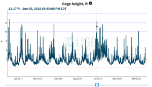
Pro Illustration extracted by author:  Gage Height Potomac on June 2, 2018.  This illustration shows the gage height during the heavy water flows on June 2, 2018. Date marked by blue square.

Also visit the National Water Dashboard link at https://waterdata.usgs.gov and go to Potomac River near Washington, DC Little

Falls Pump Station, by zooming in on the map.  Select that pump station and click the site page link on that new page.  Find the legacy real-time page link and select it.  At this link location one can search on specific parameters, such as gage height, for a date rage.  Gage height is the height of the water in the stream above a reference point. Notice how large Gage Height was on June 2, 2018 during my geological excursion.

2022 Report Updates Status of Reston’s Environmental Attributes

Photo: Provided by Northern Virginia Aerials, Reston

Article provided by Master Gardener intern/Master Naturalist Robin Duska

Ever wonder about how to measure the effects of development on the environment?
In 2017, Reston’s Environmental Advisory Committee set out to establish one approach: A baseline against which the desirability and effect of changes resulting from development or other causes could be assessed. Today, as Reston, like much of Fairfax County, accommodates ever higher population densities, it strives to maintain elements of its natural areas, water features, woodlands, and open spaces that give its residents a sense of well-being, benefit the economy, and provide a host of critically important ecological services.

The 2022 Reston Association State of the Environment Report (RASER) addresses 23 specific natural resources or environmental topics, to include many that may be of particular interest to Master Naturalists such as Streams, Stormwater, Urban Forests, Landscaping & Urban Agriculture, Birds, Wildlife Management Issues, and Light Pollution. Although Reston-focused, many of the data apply more generally to Fairfax County.

For each topic, Background information on the subject is provided, followed by a description of Existing Conditions in Reston. Conclusions are then drawn using colored traffic light icons to indicate whether the overall condition of the topic is considered good (green), fair (yellow), poor (red), or undetermined (black). RASER’s separate 2022 Report Card & Recommendations document provides a list of recommendations to better protect or improve upon Reston’s environmental conditions. It also annually
tracks the progress made on implementing previous RASER recommendations and is briefed each year to Reston’s Board of Directors. Given Reston is a census-designated area rather than a town, the Board is Reston’s decision-making body.

RASER is designed to complement the information Fairfax County’s Environmental Quality Advisory Council reports in its Annual Report on the Environment. Master Naturalists can access RASER here to read the lengthy full report, an executive summary of its conclusions, or individual chapters such as those listed above as well as the Report Card & Recommendations. Other Reston-produced environmental information is available here, including a 2021 report on best management practices for
invasive plants and Reston’s Biophilic Pledge.

The RASER project team co-led by Master Naturalist Doug Britt and Master Gardener intern/Master Naturalist Robin Duska, will welcome additional volunteers to produce the 2024 edition of RASER. Reston residents can also volunteer to serve on Reston’s Environmental Advisory Committee (EAC). To volunteer for either or both, please contact EAC’s Doug Britt at [email protected] or Surekha Sridhar at [email protected].


Image: Courtesy of The Clifton Institute

Mushroom Walk, October 14th

Saturday, October 14, 2023
2:00
– 4:00 PM

FREE

The Clifton Institute
6712 Blantyre Rd
Warrenton, VA 20187

Registration is REQUIRED.


Come to the Clifton Institute for a  fung-tastic afternoon with friends at the Mycological Association of Washington, DC to learn about mushrooms! This program will include a presentation on mushroom biology and identification followed by a walk where we’ll see how many species we can find.

Age: Adults and children accompanied by an adult.

Weather policy: Date and time subject to change dependent on weather. Please check your email for updates on the morning of the event.


The Corporate World Embraces Native Plants

Article and photo by Plant NOVA Natives

Most corporate properties have pretty “standard” landscaping, meaning the plants do very little if anything to support the local ecosystem. More and more, though, we are seeing innovative landscape designs on commercial properties that demonstrate the potential for corporations to be leaders in the effort to save the natural world, starting on their own land. While they are at it, they are creating beautiful and welcoming spaces for their clients and employees.

One example of this approach is the work done at the recently-opened Kaiser Permanente medical centers in Springfield and Woodbridge (Caton Hill). Both properties are richly landscaped with trees, shrubs, grasses and perennials that are almost entirely native to Northern Virginia. (The few exceptions are non-invasive.)

According to Alton Millwood, director of Planning, Design and Construction at Kaiser Permanente Mid-Atlantic, “The landscape design at Caton Hill Medical Center focused on allowing the natural environment to be a part of the community’s wellness plan. There is an abundance of research showing that exposure to nature can lower our heart rate, alleviate mental distress, speed recovery rates, and even alleviate symptoms of mental disorders. This is why Kaiser Permanente felt it was important to keep natural woodland areas on the project site and invite people into those space with trails and areas to sit and relax. Additionally, the native plants used on the site help to create a healthier environment by providing food and habitat for birds and other wildlife, conserving water, and reducing noise and pollution associated with mowing. It only made sense that if we were going to involve the natural environment for our own health that we would do what we could to improve the health of the environment.”

Another goal of the project was to help Northern Virginia region meet its stormwater goals to protect the local streams and the Chesapeake Bay. The planting beds and the rooftop meadow decrease the amount of runoff from impervious surfaces. Design considerations included using a variety of native plant species to provide four-season interest, using low-maintenance plants that will not require long-term watering, and choosing species that will grow to the appropriate size for their locations so that important sight lines remain open and safe.

The reaction of employees and patients alike has been extremely positive. “Many members and staff have taken advantage of the outside seating, walked through the Gardens and Health Park to immerse themselves in nature and its healing benefits, and observed the rooftop meadow flowers in full bloom, with birds and pollinators busy in their tasks.”

Asked what would be his advice to other corporations, Alton replied, “Using sustainable design practices such as planting native plants is good for people and the environment – it is a win-win. For corporations, sustainable design can impact their bottom line, too. Native plants are more likely to live long and thrive in our environment. They require less maintenance, less fertilizer and pesticides, and less water. All this adds up to savings for the owner. Hiring a like-minded design professionals can help you create places like Caton Hill Medical Center that help benefit our community and the local ecosystem.”

More photos of this and other corporate or small business landscaping projects can be found on the Commercial Landscaping page on the Plant NOVA Natives website.

Image: Courtesy of Northern Virginia Soil and Water Conservation District

Northern Virginia Soil and Water Conservation District: Soil Your Undies Campaign

Article and Images Courtesy of The Northern Virginia Soil and Water Conservation District


Soil Your Undies Campaign

Soil Your Undies Challenge

The Northern Virginia Soil and Water Conservation District is challenging residents all across Fairfax County to bury a pair of cotton underwear as part of a campaign to promote soil health awareness. How does it work? Just bury a pair of cotton underwear and dig it back up after at least 60 days. It’s the quick and dirty way to test the microbial activity in your soil. The more the underwear is deteriorated, the healthier your soil!

Although you can use the Soil Your Undies Challenge to check your soil health at any time, the most microbial activity occurs during the warm summer months, making this an easy and fun addition to your summer break plans!

Soil Your Undies Challenge Steps

Join the Challenge!

Step 1: Look for a place where you want to study the health of the soil. Make sure you are only studying sites on your property or with the permission of the landowner.

Step 2: Bury a pair of white cotton undies (or any white cotton clothing item) 3 inches under the soil’s surface. Be sure to take a “before” photo.

Step 3: Don’t forget to mark your study site with a flag or other easily-identifiable marker!

Step 4: Wait at least 60 days (this is the hard part…)

Step 5: Locate your marked study site and dig up your cotton undies. Be sure to take an “after” photo.

Step 6: How healthy is your soil? Healthier soils have a lot of microbial activity, and the healthy fungi and bacteria in the soil will break down your cotton undies. The more degraded your undies are, the more microbial activity you have in your soil, and the healthier your soil is.

Step 7: Share the results of your citizen science project! Email your photos and any notes you may have to [email protected], and share your results with us on Facebook @nvswcd and on Instagram @NorthernVirginiaSWCD. We’ll be sharing our results with you, too!

About Soil Health

Healthy soil contains billions of microbes that consume organic material (in this case, cotton underwear). In fact, one teaspoon of healthy soil contains more microbes than there are people on the planet. In addition to chowing down on organic matter like cotton, they also help soil resist erosion, cycle nutrients, and store water.

As world population and food production demands rise, keeping our soil healthy and productive is of paramount importance. By farming using soil health principles and systems that include no-till, cover cropping, and diverse rotations, more and more farmers are increasing their soil’s organic matter and improving microbial activity. As a result, farmers are sequestering more carbon, increasing water infiltration, improving wildlife and pollinator habitat—all while harvesting better profits and often better yields. In backyards, healthy soil can promote the growth of a healthy lawn and landscaping, as well as help water infiltrate and prevent erosion.

You can improve soil health by following these four steps:

  1. Avoid soil disturbance wherever and whenever possible.
  2. Maximize soil cover with living plants and residue.
  3. Maximize biodiversity by growing a variety of plants and managed integration of livestock.
  4. Maximize living roots in the soil throughout the year.
Photo credit: https://dwr.virginia.gov/wildlife/bats/

Discovering Bats in the Night Sky, October 1st

Photo credit: https://dwr.virginia.gov/wildlife/bats/

Sunday, October 1, 2023
7:00 – 8:30 PM

Where: Dyke Marsh,
Alexandria, Virginia
Click here for map and directions.

Registration required: Please visit the Better Impact website to register.

Discovering Bats in the Night Sky with Deborah Hammer, Interpretive Guide

Join us as we explore bats in the night sky at Dyke Marsh in Alexandria, VA with expert Deborah Hammer – this is open to any FMN member – and limited to the first 12 registrants! This event is eligible for one and a half continuing education hours. https://dwr.virginia.gov/wildlife/bats/

Did you know that there are over 1400 different species of bats, about 17 of which live in Virginia? Or that bananas, agave, mango, durian and guava are among the many plants pollinated by bats? If you would like to learn more fun facts, join us for an evening walk to learn all about the amazing lives of chiroptera (“hand-wing,” a.k.a. “sky puppies.”)

Using a sonar detector, participants will be able to hear the bats echolocating as they hunt for insects.

Deborah Hammer is a Fairfax Master Naturalist and serves on the boards of Bat Conservation and Rescue of Virginia and Friends of Dyke Marsh. She is also an autism/low-incidence specialist with Arlington Public Schools.

Photo FMN Deborah Hammer

Photo FMN Deborah Hammer

Registration: Please visit the Better Impact website to register.

Instructions for signing up for a hike via BI:

  1. Login to BI and click on Opportunities -> Opportunities Calendar
  2. Find event in the calendar (October 1) and click it.
  3. Click on the Sign-Up box- this will automatically register the FMN member and will put the event on your calendar.

Note: To claim CE hours: use All Continuing Education -> FMN All other Chapter Training

On day of event:

  • Please arrive by 6:45 PM to check in – We will meet at the entrance to the Haul Rd. Trail at Belle Haven Park/Dyke Marsh. The hike will begin promptly at 7:00PM.
  • Bring insect repellent. If they have a red-light flashlight, that is preferable to a traditional light.
  • Dress for the weather – wear protection as needed (e.g., rain)
  • Wear sturdy hiking shoes – we may be hiking on some trails that are wet &/or rocky
  • Bring drinking water
  • Bring a flashlight (red is preferred)

Questions? Contact Laura Anderko FMN VP and Program Chair at [email protected]

Afternoon at the Smithsonian II

This announces the second CE tour of the Smithsonian Museum of Natural History developed and tailored for VMNs by FMN John Kelmelis.
What:
Interpretive Tour of the Museum of Natural History for Virginia Master Naturalists
When:
September 27, 2023 at 3:00pm
Where:
National Museum of Natural History in DC
Meet in the rotunda at the information desk beside Henry, the big elephant.
How long:
Approximately 2 hours.
Group limit.
6 individuals
To register:
1. Login to BI and click on your ‘Opportunities’ tab.
2. Select ‘Opportunity Calendar’ from the pull-down list.
3. Find event in the calendar and click on it to display event details.
4. To sign up, Click on the ‘Sign Up’ box in the lower right. This automatically signs you up and puts the event on your personal BI calendar.
5. To claim 2 CE hours: use All Continuing Education -> FMN All other Chapter Training

Once the tour fills, the event disappears from the Opportunity Calendar but remains on the Opportunity List and your personal BI calendar.
Feel free to take notes but no audio recordings please.

FMN Dr. Kelmelis will guide an interpretive tour of the Smithsonian Institution National Museum of Natural History relevant to Virginia Master Naturalists.  This tour will identify the relationship of some exhibits to the natural environment of Virginia including the geologic history, mineralogy, entomology, osteology, evolution, mammalogy, and many other topics.  Some of the take-aways will include an introduction of how the NMNH’s display collection can be used to enrich the naturalist’s understanding of science, the scientific method, and some techniques that are applicable to naturalists’ domain of interests; as well as some facts related to the natural condition and history of Virginia.

Dr. Kelmelis is former Chief Scientist for Geography for the U.S. Geological Survey, Senior Counselor for Earth Science at the U.S. Department of State, former Professor of Science, Technology and International Policy, and Founding Faculty of the School of International Affairs at Pennsylvania State University.  He holds a BA in Earth Science; MS in Engineering; and Ph.D. in Geography.  He is a fellow of the American Association for the Advancement of Science and has held positions in many national and international scientific organizations.  He is a volunteer and docent at the Smithsonian Institution and a Virginia Master Naturalist in the Fairfax County chapter.

Advantages of Natural Science Sketching

Feature photo: Author’s covered bridge in nature setting (1970s), as self taught via the Jon Gnagy art set.

Article and illustrations by FMN Stephen Tzikas

We all have a bit of an artist in us when we learned to draw and use coloring books as children.  Some of us went further. I started self-learning art with the Jon Gnagy sets from the 1960s and 1970s.  He also had a television show.  My first dedicated art class was in 9th grade.  Among master naturalists, there are many sketchers, and I will offer my perspective on this subject.

My first application of art was with the Association of Lunar and Planetary Observer (ALPO).  They have a 1 year observing program focused on sketching astronomical objects.  What made the ALPO observation program so unique was an appreciation for details one cannot “casually see” or photograph.  When I first started this program, I was asked to pick a lunar crater and draw it as observed through a telescope.  My first sketch was not much more than a 1 minute drawing with a circle and a shadow in it.  By the time I graduated that program, I was sketching similar craters that would take me 3 hours to complete because of all the detail I could now see for which I was oblivious when I started the program. To illustrate this, I provide an example of my sketch of the crater Arzachel on the Moon.

Sketch of Moon Crater Arzachel, August 4, 2014 at Colongitude 7.97 degrees.  Magnification 169x using a Meade 12” Lightbridge telescope in Reston, VA.

Sketching details incorporate a gray tone scale (1 through 10) using different labelled pencils for this purpose. Moreover, a photograph can’t capture all the differences in live perception. Especially in astronomy, viewing gets distorted by the atmosphere. A properly identified astronomical sketch includes criteria to understand its context, such as the time and date, the object, the telescope used, and the accessories.  These sketches are accepted by various organizations as a record for future generations.   

Numerous natural science genres include colored scientific illustration, comics, and journals. Art I have seen over the decades show how illustrations have evolved, sometimes forced by necessity.  I once sketched a full Moon to compare my attempt to Galileo’s first attempt.  By then I was trained in astronomical sketching.  This feat is impossible to do in a night because many more hours would be needed than available, and keeping in mind that the shadows on the Moon are constantly changing due to movement through space.  This shadowing is defined by co-longitude and is the reason why one cannot just continue a lunar sketch the upcoming evening.  Out of necessity a style needs to be created to capture a background in a sketch and these styles evolved with time.  Style (what to accentuate) is not only a function of the historic time it was created, but also social factors that may have included materials available, social beliefs, talent, interpretations, and imagination.  The historically preserved sketch is a record of what could have existed at a time but no longer does.  Historical sketches and paintings often include environmental conditions useful to scientists, even if those works were never intended for that purpose.    

In a wider context, art can be a record of human consciousness.  The human consciousness can incorporate aspects of psychology, anthropology, and philosophy. Indeed, art can use a broad brush, to borrow a metaphor.  Art has its own unique place in nature sketching.  I would encourage others to submit articles to the FMN Newsletter as a means of preserving the various forms of art and observations for future generations. 

In addition to the FMN Newsletter as a source for art-related information, there is the art competition for the FMN recertification pins. Also, there are nature journaling meet-ups at the Clifton Institute and nature art classes are given at Hidden Oaks Nature Center.  Always available are You-tube videos on sketching. Just have a look at the fine pieces of art posted on the NOVA Nature Journal Club Facebook group at: https://www.facebook.com/groups/544583139673338

John Muir Laws also provides free videos online that have helped people become skilled observers to creatively document their experiences with nature. Experiencing the moment can sometimes be quite different from what a static photograph portrays. See the website at: https://johnmuirlaws.com/

Elk Viewing Tours, Experience Virginia’s Elk In Person!

Dates and Times (Space Limited)

  • Tuesday, September 5 @ 6 pm
  • Thursday, September 14 @ 6 pm
  • Thursday, September 21 @ 6 pm
  • Thursday, September 28 @ 5 pm
  • Thursday, October 5 @ 5 pm
  • Tuesday, October 10 @ 5 pm
  • Tuesday, October 24 @ 5 pm
  • Tuesday, October 31 @ 5 pm

Location

Tours meet at Southern Gap Outdoor Adventures (1124 Chipping Sparrow Road, Grundy VA 24614).

Cost

$20 per person

How to Sign Up

Each tour will be limited to 25 guests who will be required to pre-register through the DWR website.

Enjoy an informative guided bus tour of Virginia’s elk country in scenic Buchanan County this fall. These public elk-viewing tours, offered by the Virginia Department of Wildlife Resources (DWR) in partnership with Breaks Interstate Park, will travel through private lands, with special permission from the landowners, to view elk habitats that are otherwise inaccessible to the public. Pre-registration is required.

BOOK NOW

What to Bring

You can bring a camera, binoculars, and water. Plan on wearing footwear appropriate for the outdoors and bring a raincoat and an extra layer. (There will be some opportunities to get out of the bus.)

Policies

  • Participants under 18 years of age must be accompanied by an adult.
  • Pets are NOT allowed on the tour.
  • Unless otherwise instructed, please remain within arm’s reach of the bus.

What to Expect

Tours will last approximately 3 hours. Guides will have one or two designated stopping locations along the way where you can get out of the bus to see the elk. However, the tour and viewing of the elk will primarily take place from the bus. Tours will start and end at Southern Gap Outdoor Adventures Visitor Center, where restrooms will be available along with one stop during the tour.