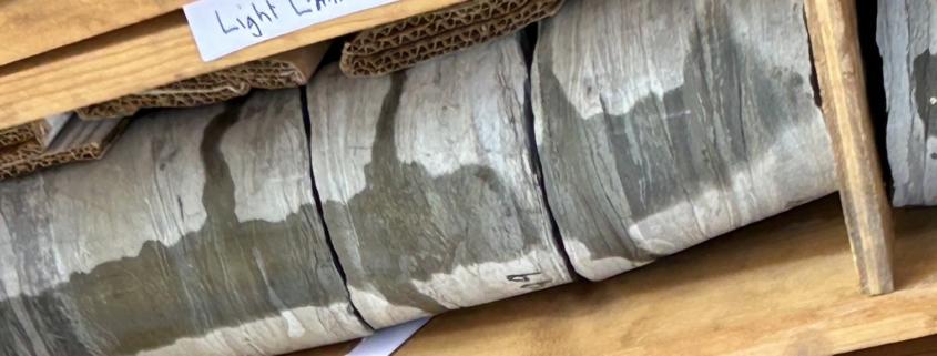
Feature photo: Fractured bedrock drill core example from the October 19, 2024 field demonstration of the annual meeting of the Geological Association of New Jersey (GANJ). A wash (squirt) bottle was used to apply water onto the drill core, whereupon demonstrating how quickly the water is absorbed into the fracture bedrock, and hence how it flows underground.
Article, photos and illustration provided by FMN Stephen Tzikas
The flow of water commonly occurs in nature. How it flows though is a whole discipline of engineering, often attempting to model flood waters or contaminants in the environment. Surface water flow and ground water flow have different dynamics. Groundwater flow can be very complicated.
In Fairfax County, our drinking water comes from the Potomac and Occoquan Rivers. The water is cleaned first at treatment plants. Into those rivers flow stormwater with pollutants and particulate matter. A lot of engineering mathematics and design goes into modeling stormwater management. The basis of this field is called fluid mechanics, which is a fundamental course for most engineering students.
Most of Fairfax County rests on top of the Piedmont Upland province, which is dominated by crystalline metamorphic bedrock like schist, granite, and gneiss, so groundwater flow depends on fractures within the bedrock. Fractured bedrock flow refers to how groundwater moves through a network of cracks, faults, and fissures in solid rock, rather than through spaces between grains of sand or soil. The USGS (United States Geological Survey) monitors local groundwater levels. You can track the real-time depth of the ground water table on the National Ground-Water Monitoring Network. The USGS has a monitoring station (with public informational displays) on its property in Reston that you can visit.
In Fairfax County observational wells are operated by Virginia DEQ (Department of Environmental Quality) and the USGS to monitor aquifer levels and flow dynamics to assess regional water availability, drought conditions, and the impact of urbanization. Local streams and groundwater are closely linked.
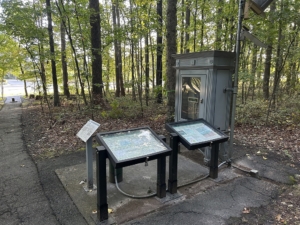
The 52V 2D USGS monitoring well is easily visited off the sidewalk on Sunrise Valley Drive and is complete with surrounding public informational displays.
The observation well 52V 2D is a U.S. Geological Survey monitoring well located at the USGS National Center in Reston, Virginia. It penetrates the Manassas Sandstone of Triassic age, tapping into an unconfined aquifer that is part of the Early Mesozoic basin aquifers. This well is situated roughly 300 feet east of the USGS National Center building at Sunrise Valley Drive in Reston, and just south of the sidewalk on Sunrise Valley Drive. The well depth is 205 feet below the land surface. It is equipped with a satellite data collection platform and recorded at 15-minute intervals. The water level at the site fluctuates in response to seasonal recharge and regional precipitation, with historical
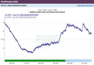
Illustration from the U.S. Geological Survey (USGS) National Water Information System: Observation well 52V 2D water monitoring data can be found on this USGS website.
measurements typically ranging between 6 and 25 feet below land surface. Historical and real-time groundwater data for this location can be reviewed on the U.S. Geological Survey National Water Information System.
Environmental engineers have an interest in groundwater management. When pollutants enter the groundwater, there are various ways, such as attenuation mechanisms, to abate the pollution. In biological degradation, microorganisms consume contaminants (like petroleum and solvents) and break them down into harmless byproducts. In chemical transformation, natural chemical reactions, such as oxidation-reduction, convert toxic compounds into less harmful forms. While working as the Environmental Chief of US Army Japan in the 1990s, we aerated the groundwater, our drinking water source, to volatize the TCE contaminant out of the water to harmless levels. TCE is trichloroethylene, an organic compound used mainly as an industrial solvent to remove grease from metal. Pollutants can originate from many sources, moving through surface water and/or infiltrating groundwater. Their fate can depend on various processes such as dispersion, degradation, volatility, or sedimentation. Rainwater can also pick up contaminants (fertilizers, pesticides, oil) and carry them into streams and lakes. Pollutants affect aquatic ecosystems and can threaten human health through drinking water contamination and exposure during recreational activities.


 Jerry Nissley