

Triassic Rocks of Horsepen Run
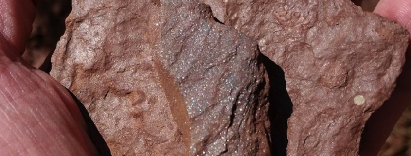
Muscovite mica glitter is apparent in a rock sample from Horsepen Run.
Article and photos by FMN Stephen Tzikas
Part of the Horsepen Run watershed is located in the northwestern part of Fairfax County. Horsepen Run eventually drains into the Potomac River. The trail that follows the creek in the watershed is popular with county residents. A part of the creek is also one of the regular sites of biological stream monitoring, a volunteer citizen science program managed by the Northern Virginia Soil and Water Conservation District. What a lot of people don’t know is that Horsepen Run is home to some interesting Triassic Period rocks, formed some 200 to 250 million years ago. A few years ago I participated in a geological field trip excursion as part of a NVCC 1-day 1-credit course that explored the geologic history of Mesozoic Era rift basin across the Manassas, Leesburg, and Haymarket areas. The excursion was specific to the Triassic and Jurassic Periods. Specific items of interest were the weathering of products; direction of transport; sediment structures; igneous rock textures and their cooling history, the rock cycle, and plate tectonics.
One of the sites investigated was the Dulles Access Road East “utility” off-road on the exit ramp for Rt. 28, at Horsepen Run. This site was the central point of a rift valley deep with sediments. Specifically, it was a lake bottom of red sediment. Some shale exists, breaking into sheets and fine grain. The rift was formed when the Earth
Horsepen Run creek at this location is composed of characteristic red rock: TRb Balls Bluff siltstone, both creek bottom and the adjacent 1-2 foot walls.
was pulled apart at the location. The rift valley is the linear shaped lowland between higher hilly and mountainous elevations created by the action of a geologic rift. Such valleys are likely to be filled with sedimentary deposits derived from the rift flanks and the surrounding areas. At this location the rock type contains Upper Triassic Balls Bluff Siltstone baked and thermally altered material. The red sediment at the location is obvious and contrasts with the appearance further upstream. The glitter found in the red rocks at this location are tiny fragments of mica.
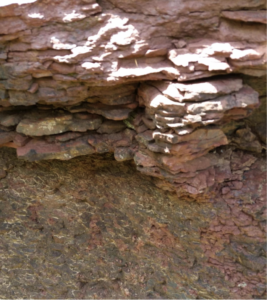
In the Triassic Period, this site was tranquil and sediments came to rest. At the Horsepen Run area, bubbles on the surface of the sediment rock indicate a calcareous (calcium based) dissolved appearance where the red rock voids still have some calcium carbonate (scattered white tones on the rocks). Occasional storms brought water from outlying edges to the center and carried some coarser material. A storm deposit from the west could bring calcium carbonate from the Leesburg conglomerate. A storm deposit episode or event could last minutes to hours.
The lacustrine (lake) facies indicated an oxygen rich environment with red color clastic deposits, allowing the oxidation of the iron. This is facies evidence, referencing the look of rock to respect of environment. If there was no oxygen we would have found black shale. Low energy would have been required for the fine grain to come to rest. Fine grains could also be due to a deep environment, but here it was more likely a shallow one of 10-15 feet, where sediments could dry. This area was a cove of low energy closed lake basin water, subject to evaporation effects. Some “circle fossil” burrow tubes also exist in the fine grain clays. Burrowing organisms lived here causing bioturbation. More evidence of the oxygen rich condition is that the taphonomic conditions were not ideal for preservation, as oxygen rich area deaths led to scavenging and organic breakdown. The terraced layers at the site alternated between siltstone and claystone, caused by changes of energy due to rainfall and climate. Higher energy means more shallow depth silt: wave energy takes away clay silt by the beach. If the climate was a little dryer, the lake would shrink, alternating between shallow and deeper cycles. These climatic cycles were tied to the Milankovitch cycles of variations in the Earth’s eccentricity, axial tilt, and precession.
You also might find some of the glittery red rocks in the surrounding area near Horsepen Run. Recently I visited the EatLoco Farmers Market at One Loudoun near Dulles airport. Between the parking lot and the vendor stalls is a strip of ground, part grassy and part flat thin red rock chips, not unlike what is found at the Horsepen Run site.