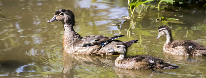
The Winter Waterfowl Count is a citizen science effort organized by Audubon Society of Northern Virginia to track data about winter waterfowl. This survey complements the Christmas Bird Count, and the data is shared openly with the public. When it started in 2008, ASNV volunteers covered the Potomac River from Algonkian Regional Park in Loudoun County to Quantico Marine Base in Prince William County, as well as many inland bodies of water. In 2020 ASNV expanded the survey by to include areas along the Potomac River in King George and Westmoreland Counties down to the mouth of the Potomac River where it empties into Chesapeake Bay. See the results from last year’s count here.
Although we expect many veterans from past years to return, we can always use new volunteers. Beginners are welcome but we strongly encourage them to attend the Duck and Waterfowl Identification webinar on February 2 and participate in the field trip on February 4. Each volunteer will be assigned to a team led by an experienced birder. Each team determines the start time, which will vary between 7 and 8:30am. End times may also vary depending on assigned survey locations.
This count is organized by Larry Cartwight. The deadline to register is Thursday, February 9 at 9:00 PM so that you can be assigned to a team in time for the count on Saturday morning.
Larry Cartwright is an avid birder and leads several avian related surveys in Northern Virginia. He lectures on birds and birding for the Lifetime Learning Institute at Northern Virginia Community College. His lecture topics have included the evolution of birds from feathered theropod dinosaurs and birding in the Alaskan tundra. Larry has received several awards from scientific and conservation organizations, including the Virginia Society of Ornithology’s Jackson M. Abbott Conservation Award for 2013.
For FMN’s: Record service hours under ASNV– C036: ASNV Waterfowl Count – Audubon Society of Northern Virginia. Please include project details in the notes section when entering service hours.
https://fairfaxmasternaturalists.org/wp-content/uploads/2019/07/Wildlife_2019.6.23-Huntley-Meadows_Ana-Kaahanui_1334.jpg40006000Mary Ann Bushhttps://fairfaxmasternaturalists.org/wp-content/uploads/2023/08/VMN-Fairfax-cmyk_w223h156.jpgMary Ann Bush2023-01-05 11:56:282023-01-05 11:56:28Winter Waterfowl Count, February 11th and 12th
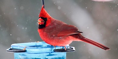
Project FeederWatch is the easiest citizen science you will ever do!
From the comfort of your home, you simply count the winter birds that visit your feeders and report your data to Cornell Lab of Ornithology.
This FREE workshop will cover a bit of Project FeederWatch history, its purpose, tips for identifying birds, and the protocols to be followed while counting. After the presentation, your identification skills will be tested with a Kahoot!
Greg Butcher is a Ph.D. ornithologist and Audubon Society of Northern Virginia(ASNV) board member. In addition to the U.S. Forest Service, Greg has worked for the National Audubon Society, American Birding Association, Partners in Flight, Birder’s World magazine, and Cornell Lab of Ornithology. Greg is a lively and informative public speaker and interpreter for bird conservation and ecology worldwide.
https://fairfaxmasternaturalists.org/wp-content/uploads/2022/11/ASNV_Northern-Cardinal_Alexis-Hayes.jpg194389Mary Ann Bushhttps://fairfaxmasternaturalists.org/wp-content/uploads/2023/08/VMN-Fairfax-cmyk_w223h156.jpgMary Ann Bush2022-11-03 15:11:132022-11-03 16:27:48ASNV Project FeederWatch Workshop with Greg Butcher, November 22nd
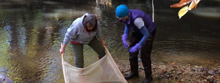
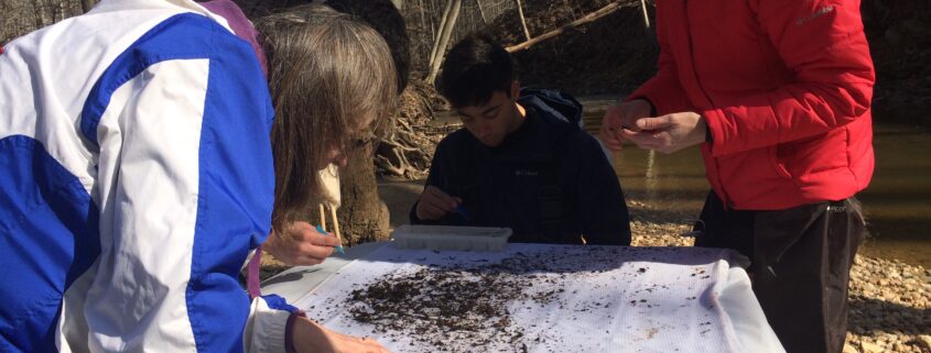
Below is a list of Stream Monitoring Citizen Science, Workshops, and other monitoring opportunities in the area for August and September.
*NVSWCD Workshop*
Difficult Run Stream Monitoring Workshop
When: Sunday, August 21, 10:00am-12:30pm
Where: Difficult Run Stream Valley Park, Great Falls
This quiet site is known for numerous macros and a relatively high stream score. In spring we found a high number of midges – will we find the same this visit? Space is limited, please register for the workshop here.
*NVSWCD Workshop*
Horsepen Run Stream Monitoring Workshop
When: Saturday, August 27, 9:00-11:30am
Where: Horsepen Run Stream Valley Park, Herndon
This stream site parallels the park trail and is a favorite with local runners, bikers, and dog walkers! This site scored higher in the spring monitoring than it had in past years – join us to see if this positive trend continues! Space is limited, please register for the workshop here.
Creek Critters Count and Catch Program
When: Sunday, August 28, 1:00pm
Where: Chapman DeMary Trail, Purcellville
Join the Purcellville Parks and Recreation Advisory Board, Purcellville Tree and Environment Sustainability Committee and Loudoun Wildlife Conservancy to get up close and personal with the creek critters living in the South Fork of the Catoctin Creek at the Chapman DeMary Trail. Loudoun Wildlife Stream Team members will discuss the natural history of these critters, help participants learn how to identify them, and explain how they can help us determine the health of a stream. Registration required through Purcellville Parks and Recreation website. Learn more here.
Friends of Accotink Creek Biological Stream Monitoring
When: Saturday, September 10, 9:30-11:30am
Where: Lake Accotink Park, Springfield
Volunteers assess ecological conditions in the stream, based on the presence and abundance of bottom-dwelling invertebrates. Meet at the parking lot behind Lake Accotink Park Administrative building. RSVP.
*NVSWCD Workshop*
Wolftrap Creek Stream Monitoring Workshop
When: Saturday, September 10, 1:00-3:30pm
Where: Wildwood Park, Vienna
This site was recently made available for adoption after it’s monitor moved away for college. Come see how sites are monitored and how you can join our volunteer team! Space is limited, please register for the workshop here.
*NVSWCD Workshop*
Cub Run Stream Monitoring Workshop
When: Sunday, September 25, 9:00-11:30am
Where: Cub Run Stream Valley Park, Centreville
This stream site had great stream health scores in the spring – come see if the trend continues! As a bonus treat, this site often has delicious pawpaws ripening this time of year… Space is limited, please register for the workshop here.
PocketMacros App – macroinvertebrate ID on Android and Apple
The Northern Virginia Water and Soil Conservation District (NVSWCD) is very excited to contribute their stream data to state and national datasets. If you’d like to see data from all the NVSWCD regional stream monitoring team’s active sites, you can find our organization on the Clean Water Hub. Keep in touch with NVSWCD on our Facebook and Instagram.
https://fairfaxmasternaturalists.org/wp-content/uploads/2018/11/IMG_6312.jpg24483264Mary Ann Bushhttps://fairfaxmasternaturalists.org/wp-content/uploads/2023/08/VMN-Fairfax-cmyk_w223h156.jpgMary Ann Bush2022-08-09 15:59:252022-08-09 15:59:25Stream Monitoring: Citizen Science & Training Opportunities – August and September
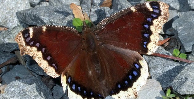
Photo: Courtesy of Plant NOVA Natives, Mourning Cloak Butterfly
Every Friday, April-October, 2022
8:30am-12:00pm
Various locations:
Meadowood Recreation Area10406 Gunston Road
Lorton, VA, 22079
Occoquan Bay NWR13950 Dawson Beach Road
Woodbridge, VA, 22191
Metz Wetlands15875 Neabsco Road
Woodbridge, VA, 22191
Occoquan Regional Park9751 Ox Road
Lorton, VA, 22079
Registration is required, to learn more and to register, click here.
Butterfly and dragonfly surveys are carried out in temperate months (April-October), normally on Friday mornings, at one of four sites around Occoquan Bay, all within the 15-mile diameter circle established for the annual North American Butterfly Association‘s Annual Count.
https://fairfaxmasternaturalists.org/wp-content/uploads/2020/10/unnamed-4.jpg469629Mary Ann Bushhttps://fairfaxmasternaturalists.org/wp-content/uploads/2023/08/VMN-Fairfax-cmyk_w223h156.jpgMary Ann Bush2022-07-08 17:22:592022-07-14 16:26:29Butterfly and Dragonfly Survey, April – October
Below is a list of Stream Monitoring Citizen Science, Workshops, and other monitoring opportunities in the area for July and August.
*NVSWCD Workshop
Pohick Creek Stream Monitoring Workshop
When: Sunday, July 17, 10:00am-12:30pm
Where: Hidden Pond Nature Center, Springfield
This is the workshop site of a recently-retired stream monitor and is currently up for adoption. Come join us at this beautiful county park! Space is limited, please register for the workshop here.
*NVSWCD Workshop
Holmes Run Stream Monitoring Workshop
When: Saturday, July 23, 9:00-11:30am
Where: Holmes Run Stream Valley Park, Falls Church
This workshop site is an easily-accessible location just downstream of Lake Barcroft. Come explore this beautiful spot in the Cameron Run watershed! Space is limited, please register for the workshop here.
*NVSWCD Workshop
Difficult Run Stream Monitoring Workshop
When: Sunday, August 21, 10:00am-12:30pm
Where: Difficult Run Stream Valley Park, Great Falls
This quiet site is known for numerous macros and a relatively high stream score. In spring we found a high number of midges – will we find the same this visit? Space is limited, please register for the workshop here.
*NVSWCD Workshop
Horsepen Run Stream Monitoring Workshop
When: Saturday, August 27, 9:00-11:30am
Where: Horsepen Run Stream Valley Park, Herndon
This stream site parallels the park trail and is a favorite with local runners, bikers, and dog walkers! This site scored higher in the spring monitoring than it had in past years – join us to see if this positive trend continues! Space is limited, please register for the workshop here.
*Northern Virginia Water and Soil Conservation District
Creek Critters Count and Catch Program
When: Sunday, August 28, 1:00pm
Where: Chapman DeMary Trail, Purcellville
Join the Purcellville Parks and Recreation Advisory Board, Purcellville Tree and Environment Sustainability Committee and Loudoun Wildlife Conservancy to get up close and personal with the creek critters living in the South Fork of the Catoctin Creek at the Chapman DeMary Trail. Loudoun Wildlife Stream Team members will discuss the natural history of these critters, help participants learn how to identify them, and explain how they can help us determine the health of a stream. Registration required through Purcellville Parks and Recreation website. Learn more here.
PocketMacros App – macroinvertebrate ID on Androidand Apple
The Northern Virginia Water and Soil Conservation District (NVSWCD) is very excited to contribute their stream data to state and national datasets. If you’d like to see data from all the NVSWCD regional stream monitoring team’s active sites, you can find our organization on the Clean Water Hub. Keep in touch with NVSWCD on our Facebook and Instagram.
https://fairfaxmasternaturalists.org/wp-content/uploads/2019/04/IMG_6501.jpg24483264Mary Ann Bushhttps://fairfaxmasternaturalists.org/wp-content/uploads/2023/08/VMN-Fairfax-cmyk_w223h156.jpgMary Ann Bush2022-07-08 13:53:382022-07-08 13:54:51Stream Monitoring: Citizen Science & Training Opportunities
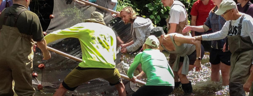
Below is a list of the various Stream Monitoring workshops and other monitoring opportunities in the area throughout June and July.
Accotink Creek Stream Monitoring
When: Saturday, June 11, 9:30 – 11:30am
Where: Accotink Creek, Springfield
Join Friends of Accotink Creek to monitor the health of the stream. For more information and to register, click here.
Little Hunting Creek Stream Monitoring Workshop
When: Sunday, June 12, 10:00am-12:30pm
Where: Paul Spring Stream Valley Park, Alexandria
This workshop was originally scheduled for April but was rained out… twice! Take this opportunity to join us as we visit the Paul Spring Branch of Little Hunting Creek for the first time in many years! Space is limited, please register for the workshop here.
Sugarland Run Stream Monitoring Workshop
When: Tuesday, June 21, 4:00-6:30pm
Where: Sugarland Run Stream Valley Park, Herndon
This site is close to one of the largest great blue heron rookeries in the area at Kincora along Route 28, and seeing these beautiful birds along Sugarland Run isn’t uncommon. What a nice bonus to complement Sugarland Run’s big crayfish and other mighty macros! Space is limited, please register for the workshop here.
Pohick Creek Stream Monitoring Workshop
When: Sunday, July 17, 10:00am-12:30pm
Where: Hidden Pond Nature Center, Springfield
This is the workshop site of a recently-retired stream monitor and is currently up for adoption. Come join us at this beautiful county park! Space is limited, please register for the workshop here.
Holmes Run Stream Monitoring Workshop
When: Saturday, July 23, 9:00-11:30am
Where: Holmes Run Stream Valley Park, Falls Church
This workshop site is ae easily-accessible location just downstream of Lake Barcroft. Come explore this beautiful spot in the Cameron Run watershed! Space is limited, please register for the workshop here.
PocketMacros App – macroinvertebrate ID on Android and Apple
The Northern Virginia Water and Soil Conservation District(NVSWCD) is very excited to contribute their stream data to state and national datasets. If anyone would like to see data from all the NVSWCD regional stream monitoring team’s active sites, the NVSWCD organization can be found on the Clean Water Hub. Keep in touch with NVSWCD on our Facebook and Instagram.
https://fairfaxmasternaturalists.org/wp-content/uploads/2019/04/IMG_6501.jpg24483264Mary Ann Bushhttps://fairfaxmasternaturalists.org/wp-content/uploads/2023/08/VMN-Fairfax-cmyk_w223h156.jpgMary Ann Bush2022-06-07 18:05:512022-06-07 18:05:51Stream Monitoring: Citizen Science & Training Opportunities
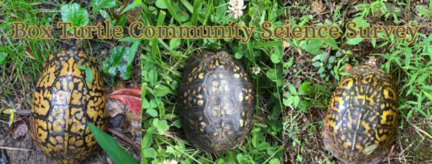
The Clifton Institute is starting a research project to study box turtles. They want to know what habitats they use, what time of year they’re most active, how big their territories are and how much overlap neighboring territories have, and most importantly what can be done to help conserve this long-lived species. To start, they need to have a better idea of how many box turtles there are on their property and where they can find them. The Clifton Institute needs your help! In late May or early June, they are going to wait for rainy weather and spend a day walking all of the trails looking for box turtles. They will divide registrants into teams to cover more ground. The more eyes the better! No experience is needed. Volunteers will be walking on uneven and potentially steep trails.
They chose May 18 as the date they expect to be the earliest possible survey date, but they will wait for the right weather and email registrants with more information.
https://fairfaxmasternaturalists.org/wp-content/uploads/2022/04/Clifton_institute_Box_turtles.jpg237624Mary Ann Bushhttps://fairfaxmasternaturalists.org/wp-content/uploads/2023/08/VMN-Fairfax-cmyk_w223h156.jpgMary Ann Bush2022-04-14 14:57:412022-04-21 20:40:06Box Turtle Community Science Survey, May 18th, weather dependent
Citizen science is the involvement of people who are not professional scientists in real forms of scientific study. Through the Virginia Master Naturalist program, citizen scientists are making important contributions to natural resources research and conservation, greatly increasing the capacity of professional scientists and land managers. Join Michelle Prysby, Director of the Virginia Master Naturalist program, to explore examples of impactful citizen science and to learn how you can get involved in citizen science, regardless of your background.
Michelle Prysby is the Director of the Virginia Master Naturalist program and an Extension faculty member in the Department of Forest Resources and Environmental Conservation at Virginia Tech.
Please note that this webinar is being hosted by Virginia Tech’s College of Natural Resources and Environment’s Advancement Team as part of their monthly Lunch and Learn Series for alumni and any others interested in joining.
https://fairfaxmasternaturalists.org/wp-content/uploads/2022/02/unnamed.jpg8001200Janet Quinnhttps://fairfaxmasternaturalists.org/wp-content/uploads/2023/08/VMN-Fairfax-cmyk_w223h156.jpgJanet Quinn2022-02-06 16:24:542022-02-06 16:24:54Citizen science in natural resources: How volunteers are making a difference, webinar February 17th
By FMN C.E. Hike Coordinator Barbara J. Saffir (iNat username: DMVphotographer)
WHY USE INATURALIST?
If you want to contribute to citizen-science while exploring outdoors, iNaturalist’s free, user-friendly app and website provides the best virtual toolbox. Your data will actually get used. Real humans are available to respond to problems. You can join projects and interact directly with other observers around the globe. Plus, it’s downright fun! And iNat is powered by a world-class team of experts at the National Geographic and the California Academy of Sciences.
But before you start snapping pictures, learn how to improve your photos so your observations can be identified easier by iNat’s artificial intelligence, which, in turn, helps scientists more. Some helpful camera tips follow. But in some cases, it also helps to learn when you need to photograph specific parts of some critters or plants to identify them.
CAMERA
Whether you use a cell phone camera, a DSLR, a mirrorless, or a point-and-shoot, its best to learn your camera’s capabilities by practicing and by studying its manual.
APP OR WEBSITE?
Most of the time I photograph and upload directly from iNaturalist’s app because it’s faster, easier, and it’s the sole photo app I allow to use my location, due to privacy. Also, if I have cell service, I can identify observations in the field and upload them immediately — though I usually wait until I’m connected to a power source since those functions use a lot of “juice.”
However, instead of relying solely on unaltered photos uploaded directly from the app’s camera, your photos will be better if you tweak them first with a third-party processing program like Photoshop. In less than 60 seconds, you can often improve the composition (via cropping), lighting, sharpness, and more before uploading them to iNat. If you upload using your computer, you can batch-edit the dates and locations. The website is also better at identifying critters and plants because it gives you ranges and can confirm if observations of your organism have already been made in that county, adds a local science teacher who identifies thousands of iNat observations. She also recommends that you should only identify what you, yourself, can confirm. For example, she says if iNat suggests a “two-spotted bumble bee” but you’re only sure it’s a “bumble bee,” stick with that. Of course, beginners and/or casual users have to rely on iNat’s suggestions until they learn more.
BASICS FOR IMPROVING PHOTOS:
1. IN FOCUS:Look at your photo right away and if it’s not in focus, take another until it’s sharp.
2. SUBJECT SHOULD TAKE UP MOST OF THE FRAME:Get as close as feasible. Crop your photos to cut out major distractions, such as other species, weeds, and sticks. Don’t crop too much or it will result in poor resolution. Also, don’t waste your time using “digital zoom” on a camera because of its poor quality — unless you’re far away and you spot the Loch Ness Monster or Brad Pitt.
3. WELL-LIGHTED: Keep the sun behind you. Use flash or a flashlight if needed.
4.ADDITIONAL VIEWS MAY BE NEEDED FOR ID: Sometimes a close-up detail of an organism’s features, such as its underside, bark, leaves, head, etc., is needed. (See below for iNat’s ID tips.)
5.ADD SCALE IF NECESSARY: Use your finger, a ruler, a penny, etc.
6.NOTES: You can add notes to your observations, such as the number of plants or critters observed. You can also add that you shot a video if anyone wants to see it.
7.MISCELLANEOUS: Clean your lens before photographing. Check your battery. Use your foot, your chest, a tree, a fence, or another solid object as a makeshift tripod to prevent the camera from shaking. For plant photos, bring a piece of cardboard for a backdrop and to block the wind. Join iNat projects to share your finds with people who care about them most. Join local bioblitzes, such as City Nature Challenge each spring and Fairfax County Park Authority’s occasional bioblitzes.
INATURALIST’S PHOTO TIPS:To pinpoint certain species, such as mushrooms, flowers, turtles, snakes, and birds, it’s best to learn about those subjects independently to know what kind of details are required to clinch an ID of specific species. For example, with birds, it helps to photograph the entire bird, and to document important details, such as its color, shape, size, beak, behavior, habitat, and feather field marks (such as an eye ring or bars on its feathers) with photo(s) or in notes. https://www.inaturalist.org/guides/2465
Lena Struwe and Peter Nitzsche, Rutgers University
DISCOVERY TIME: So now that you’re prepared to contribute better photos to help citizen-science, the only question is: “Where should I go hunting for nature today?” You don’t even have to venture far from home. Fairfax County has more than 400 parks along nearly 1,000 miles of paved and dirt trails. Maybe you’ll even discover a whole new species. This year, Virginia Tech discovered a new species of millipedes on its own campus.
https://fairfaxmasternaturalists.org/wp-content/uploads/2021/10/Barbara.jpeg9071375Janet Quinnhttps://fairfaxmasternaturalists.org/wp-content/uploads/2023/08/VMN-Fairfax-cmyk_w223h156.jpgJanet Quinn2021-10-06 17:12:482021-10-06 17:12:48How to Improve Your iNaturalist Photos to Better Help Scientists
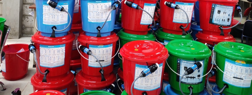
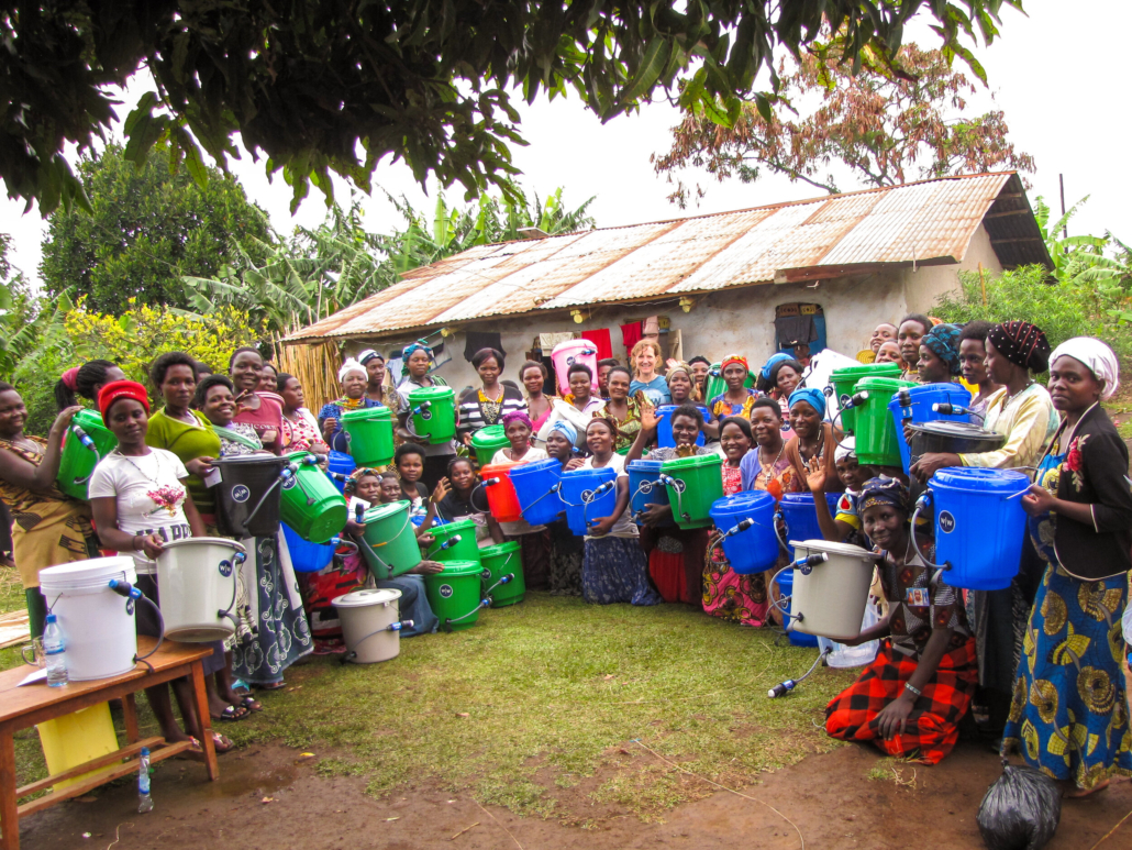
Conservation, community service, hands-on environmental engineering, and social justice intersect in the work of Wine to Water, a North Carolina-based 501 (c) (3) nonprofit whose mission is to support life and dignity through the power of clean water.
The organization enables many ways to participate, one of which is Filter Build, a guided experience to build small, portable water filters that the organization distributes to communities in the U.S., Colombia, The Dominican Republic, Nepal, Tanzania, and elsewhere. Here is a copy of their 2018-2019 Annual Report, which presents the results of their work in both quantitative and human terms.
Do Fairfax County residents need these filters themselves? Nope.
Can Fairfax County residents and Master Naturalists host virtual events to actually build them for communities that do? You bet.
Might we, our children and grandchildren, and our neighbors learn about some of the engineering that goes into making water potable? Yup, that, too.
https://fairfaxmasternaturalists.org/wp-content/uploads/2020/12/Wine-to-Water-Filter-Build-Program-e1607778507952.jpg421500vmnfairfaxhttps://fairfaxmasternaturalists.org/wp-content/uploads/2023/08/VMN-Fairfax-cmyk_w223h156.jpgvmnfairfax2020-12-12 13:12:192020-12-12 14:53:17Wine to Water Filter Build: Create A Meaningful Experience for Your Family and Community