Posts

Geology of the Piedmont Tour, March 9th

Image: Courtesy of Clifton Institute

Saturday, March 9, 2023
9:00AM – 12:00PM

The Clifton Institute
6712 Blantyre Rd
Warrenton, VA 20187

Cost: FREE

Registration is REQUIRED.

It’s winter and that means that rock season is upon us! This year, it would be nice to branch out and check out a whole new geologic province. The last two years the class took a close look at rocks of the Piedmont Plateau and learned that several times in the geologic past, huge mountain ranges rose up where the Piedmont is today. Where did those mountains go? The sand and silt washed down from those soaring peaks must have gone somewhere and this class is going to find it! Join this tour for a journey off the western edge of the Blue Ridge Anticlinorium and into one of the world’s great thrust/fold belts, the Valley and Ridge Province of the Appalachian Mountains. you will be looking at layers and layers of ancient sediments laid out in a vast river delta. Like the pages of a book, these layers have a fascinating story to tell about life in the Paleozoic.

The tour will be heading out to Front Royal to begin the geology tour this year and making its way up into Fort Valley, stopping along the way. A few of the stops will involve a short hike but nothing too strenuous.

Participants can EITHER meet at Clifton at 9 a.m. and carpool to Front Royal, OR meet the tour in Front Royal around 10 a.m.

Ode on a Fish Fossil

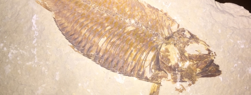
Feature photo: Fish Fossil, Green River Formation, Western United States.

Article and photos by FMN Stephen Tzikas

Heard melodies are sweet, but those unheard
Are sweeter; therefore, ye soft pipes, play on;
Not to the sensual ear, but, more endear’d,
Pipe to the spirit ditties of no tone

So goes the second stanza of John Keats’ “Ode on a Grecian Urn” that I vividly remember from my High School days. These were the same words that flashed in my mind upon viewing a fish fossil my friend gave me a few months ago. Funny thing it is, how the poet sometimes seems to precede the scientist in me.

The famous English poet’s ode appreciates the timeless art on an urn, and so too, the fish fossil in my mind was a presentation of beauty and immortality, having patiently waited millennia to tell its story. And just as in the original poem, we have the conclusion of the poem which can equality apply to the fish fossil:

When old age shall this generation waste,
Thou shalt remain, in midst of other woe
Than ours, a friend to man, to whom thou say’st,
“Beauty is truth, truth beauty,”—that is all
Ye know on earth, and all ye need to know.

While these herring fish fossils have their origin in the limestone of the Green River Formation, residents of Fairfax County do not need to go that far, or even leave the county, to find fossils.

My exposure to fossils began as a child reading the How and Why Wonder Book of Dinosaurs, which indicated that the first, near complete, skeleton of a dinosaur was discovered in Haddonfield, NJ. Since that was in my home state, I hoped to visit the town one day. Eventually I would indeed visit that town to see the Hadrosaurus statue commemorating the find in 1858 that started the field of dinosaur paleontology.

During the Triassic Period (201 – 252 Mya), dinosaurs left behind both bones and footprints in Virginia. Fish from local lakes were preserved during the Jurassic (145 – 201 Mya). In the 1920s, dinosaur tracks were discovered at nearby Oak Hill. The Northern Virginia Community College (NVCC) offers many one-day one-credit geology excursions in our general area. I completed many of these courses and had the opportunity to see fossils during these excursions.

On June 24, 2017, I attended the geological field study trip for the

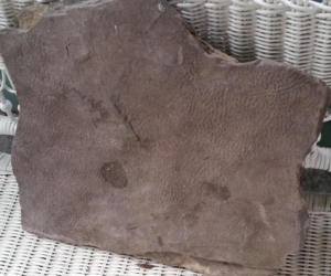
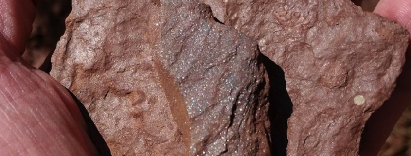
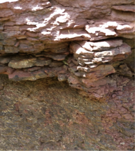
Oak Hill Dinosaur Skin Print, June 24, 2017, 1.5 by 2 Foot Scale

Triassic-Jurassic Rifting of North America in the Triassic Lowlands of Northern Virginia. One of the sites on that trip was the Oak Hill Estate (Home of President James Monroe). This site contains dinosaur tracks. The rock type here is the Lower Jurassic Turkey Run Formation (197 Mya). The fossils are of Eubrontes foot tracks and a rare skin print (see my photograph). Also fossilized was a lungfish burrow from the Jurassic, which had estivated to survive through the summer. Ripples, raindrops imprints, and bioturbation were evident in fossils we saw.

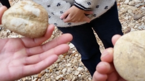
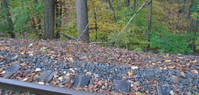
Photo:Holmes Run Gorge Fossils, Nov 18, 2017. Shown here are fossils (Skolithos Linearis) in well-cemented quartzite of the early Antietam Formation. These are Virginia’s oldest fossils and date to the Cambrian Period (485 – 539 Mya).

On November 18, 2017, I took another NVCC geology excursion for the Geologic History of Holmes Run Gorge at the Dora Kelley Nature Park in Alexandria. At the main gorge area we discussed the quartz rocks. Quartz is the last mineral in the Bowen reaction series of fractional crystallization.

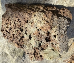
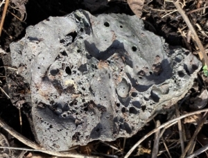
I find the Bowen reaction series fascinating as it has some correlation to fractional distillation in my field of chemical engineering. I collected a sample of cloudy white milky quartz, which is extremely resistant to weathering. The cloudiness of milky quartz comes from microscopic inclusions of fluids that have been encased in the crystal from the time the crystal first grew. Our professor showed multiple examples of Quartzite with slashes (see my photograph). High-energy waters transported these cobblestone size rocks originating from the Harper’s Ferry Antietam Formation. The formation was largely quartz sandstone with some quartzite and quartz schist. This formation underwent metamorphic changes. This Quartzite is a hard, non-foliated metamorphic rock that was originally pure quartz sandstone. The sandstone was converted into quartzite through heating and pressure usually related to tectonic compression within orogenic belts. Most noteworthy were the tubeworm line burrows, about a half billion years old. Samples were numerous.

The Volcano Near Fairfax County

A photograph of Mole Hill as seen along Route 33.

Article and photo by FMN Stephen Tzikas

When I travel to the Society of Amateur Radio Astronomers (SARA) annual conference every summer at the Greenbank Observatory in West Virginia, I drive along Route 33 just past Harrisonburg, VA, the home of James Madison University (JMU). It’s a rural road, but something unusual is found there – a volcano. It’s called Mole Hill, quite inactive today, but nearly 50 million years ago magma thrusted upwards to the surface through cracks in the lithosphere. The tree covered Mole Hill as seen today is made of remnants of the cooled magma column, eroding at a slower pace than the sedimentary rock around it. That resistant rock that supports the peak is a volcanic plug of olivine basalt. This basalt is dark greenish gray to grayish black, medium grained, and moderately porphyritic. Mole Hill is one of the youngest volcanoes on the east coast of North America. Mole Hill has a height of nearly 1,900 feet above sea level. Another extinct volcano, Trimble Knob, is a little closer to the Greenbank Observatory and a little farther from Fairfax County.

Dr. W. Cullen Sherwood of JMU, who passed away in 2016, gave a brief account of Mole Hill and its geology at the following link: https://csmgeo.csm.jmu.edu/geollab/vageol/outreach/fieldtrips/rockingham/molehill.html

His illustration gives the reader an idea of how Mole Hill may have originally appeared.

Mole Hill is mentioned in the Roadside Geology of Virginia book by Keith Frye. The books in the Roadside Geology Series are an excellent way to explore the geology around us when we travel along roads through different states. These books are available through Amazon.com.


Triassic Rocks of Horsepen Run

Muscovite mica glitter is apparent in a rock sample from Horsepen Run.

Article and photos by FMN Stephen Tzikas

Part of the Horsepen Run watershed is located in the northwestern part of Fairfax County. Horsepen Run eventually drains into the Potomac River. The trail that follows the creek in the watershed is popular with county residents. A part of the creek is also one of the regular sites of biological stream monitoring, a volunteer citizen science program managed by the Northern Virginia Soil and Water Conservation District. What a lot of people don’t know is that Horsepen Run is home to some interesting Triassic Period rocks, formed some 200 to 250 million years ago. A few years ago I participated in a geological field trip excursion as part of a NVCC 1-day 1-credit course that explored the geologic history of Mesozoic Era rift basin across the Manassas, Leesburg, and Haymarket areas. The excursion was specific to the Triassic and Jurassic Periods. Specific items of interest were the weathering of products; direction of transport; sediment structures; igneous rock textures and their cooling history, the rock cycle, and plate tectonics.

One of the sites investigated was the Dulles Access Road East “utility” off-road on the exit ramp for Rt. 28, at Horsepen Run. This site was the central point of a rift valley deep with sediments. Specifically, it was a lake bottom of red sediment. Some shale exists, breaking into sheets and fine grain. The rift was formed when the Earth

Horsepen Run creek at this location is composed of characteristic red rock: TRb Balls Bluff siltstone, both creek bottom and the adjacent 1-2 foot walls.

was pulled apart at the location. The rift valley is the linear shaped lowland between higher hilly and mountainous elevations created by the action of a geologic rift. Such valleys are likely to be filled with sedimentary deposits derived from the rift flanks and the surrounding areas. At this location the rock type contains Upper Triassic Balls Bluff Siltstone baked and thermally altered material. The red sediment at the location is obvious and contrasts with the appearance further upstream. The glitter found in the red rocks at this location are tiny fragments of mica.

In the Triassic Period, this site was tranquil and sediments came to rest. At the Horsepen Run area, bubbles on the surface of the sediment rock indicate a calcareous (calcium based) dissolved appearance where the red rock voids still have some calcium carbonate (scattered white tones on the rocks). Occasional storms brought water from outlying edges to the center and carried some coarser material. A storm deposit from the west could bring calcium carbonate from the Leesburg conglomerate. A storm deposit episode or event could last minutes to hours.

The lacustrine (lake) facies indicated an oxygen rich environment with red color clastic deposits, allowing the oxidation of the iron. This is facies evidence, referencing the look of rock to respect of environment. If there was no oxygen we would have found black shale. Low energy would have been required for the fine grain to come to rest. Fine grains could also be due to a deep environment, but here it was more likely a shallow one of 10-15 feet, where sediments could dry. This area was a cove of low energy closed lake basin water, subject to evaporation effects. Some “circle fossil” burrow tubes also exist in the fine grain clays. Burrowing organisms lived here causing bioturbation. More evidence of the oxygen rich condition is that the taphonomic conditions were not ideal for preservation, as oxygen rich area deaths led to scavenging and organic breakdown. The terraced layers at the site alternated between siltstone and claystone, caused by changes of energy due to rainfall and climate. Higher energy means more shallow depth silt: wave energy takes away clay silt by the beach. If the climate was a little dryer, the lake would shrink, alternating between shallow and deeper cycles. These climatic cycles were tied to the Milankovitch cycles of variations in the Earth’s eccentricity, axial tilt, and precession.

You also might find some of the glittery red rocks in the surrounding area near Horsepen Run. Recently I visited the EatLoco Farmers Market at One Loudoun near Dulles airport. Between the parking lot and the vendor stalls is a strip of ground, part grassy and part flat thin red rock chips, not unlike what is found at the Horsepen Run site.

Geology Adventures: Man-Made Slag

Feature photo:  Slag Nuggets line this railroad track near Willoughby Brook, High Bridge, NJ

Article and photos by FMN Stephen Tzikas

Not too far from Fairfax County is geologic treasure. Engineers love it. It is a by-product of iron ore smelting, one of the oldest chemical engineering processes. The by-product is called slag and it is unique and beautiful.

A few years ago I stopped at the Burden Iron Works in Troy, NY on my way to Rensselaer Polytechnic Institute (RPI) for Reunion and Homecoming not far from the iron works. The iron works are not a big tourist attraction, so I had to call the curator for an appointment. The meeting I had with curator was just grand. We talked at least a couple hours on the engineering history of the area which included RPI. Before leaving he took me outside to walk the perimeter of the iron works

Catoctin Furnace Slag Nugget Sample 1.  Vesicles pockmark this brownish and green tone slag sample.

and told me about slag. Slag is the rock remaining after iron is extracted from the ore. The property and surrounding area has some slag scattered around. He told me it can usually be found easily along a building perimeter because that’s where it’s thrown by ground keepers who cut grass and don’t like hitting it with the mowers. He gave me a few pieces of the century-plus old slag and I finally departed.

Later, at the Jonsson-Rowland Science Center building at RPI, while looking at the geologic collection located there, a graduate student came out of his research lab and I struck up a conversation with him on the Burden Iron Works. He quickly went back into his lab to pull out a slag sample from the iron works in which some residue ore in a large slag sample formed a colorful blue glass mix with the ore. Impressed, I have ever since included old iron furnace stops on my road trips. If you keep in mind that slag samples are likely to be located along perimeter building ruins, you’ll find interesting nuggets. One especially pleasing location is the Lock Ridge Furnace Museum if you are passing through the Allentown, PA area. There are literally thousands of slag samples all over the grounds. It is much rarer to find slag samples with colorful shades of glass in them, but if you are curious, do a google image search on “colored iron slag” to see what I mean. Some slag samples can also be magnetic, and the color of a slag sample is due to the different mixes of elements and leftover metals in it.

Catoctin Furnace Slag Nugget Sample 2. Vesicles and Blebs are found in this gray slag sample.

Iron smelting was a big industry in the 18th and 19th century America, and you can usually find industrial furnace ruins from that period everywhere that had settlements. My stops at old furnaces usually take me through Pennsylvania on my trips to NJ and NY. However, we have local furnace ruins too. One nearby is the Catoctin Furnace in Thurmont, MD. This is a 19th century iron works and the website can be found at https://catoctinfurnace.org/village/

Slag samples could appear in a variety of other places too. The iron industry of yesteryear produced so much slag waste, the industry found uses for it. Iron ore slag is generally safe. It is just ore rock with the iron removed. While hiking in High Bridge, NJ one day, I came across large amounts of it lining the railroad tracks (along Buffalo Hollow Road near Willoughby Brook, and just off of Cregar Road). The slag made a suitable material cushioning the track area from the extended environment. Normally, one might see other forms of crushed stone gravel around railroad tracks. If you come across railroad tracks in your nature trail excursions, take a look at whether the tracks have stone ballast in the track bed, and whether it is slag.

If I have interested you to build a slag collection, please be aware that some parks might have rules requiring visitors not to remove anything from a site. Such rules, if they exist, are usually posted so visitors know. Now that you are aware, keep your eyes open for interesting geology on the ground at old furnace ruins.


Below the Surface: How Plants & Geology Interact, webinars March 8th & 15th

Tuesdays, March 8 and 15, 2022
6:30 pm, meet and greet both evenings
Sessions start at 7pm and 8pm both evenings
Please register only once for both sessions

Join Virginia Native Plant Society for either or both evenings on geology and plants. March 8th’s sessions topics are Land Management Lessons from Piedmont Prairies and Virginia’s Geology. On March 15th the topics are Geology and Soil Parent Materials as Determinants of Natural Communities in Virginia and the Carolinas and Beyond Substrates.

Keep learning with Smithsonian Museum of Natural History webcasts

Smithsonian Science How

Bring a Smithsonian Scientist into your classroom with Smithsonian Science How! Check out the Science How schedule below to get started, or preview our formats by watching a program from our video webcast archives.

Video Webcasts

These free, interactive, live video webcasts take questions from your students while introducing them to science concepts and practices through the lens of Smithsonian research and experts. The shows provide opportunities for your students to interact via live polls and Q&A with the scientist.

  • Grades 3-8; optimized for students in grades 3-5
  • Developed in collaboration with the Smithsonian’s children’s theater, Discovery Theater
  • Scientists take your questions
  • Complementary teaching resources
  • 30 minutes long
  • Aligned with national science standards

Schedule

Here is the webcast schedule for the 2019-2020 school year. Want to suggest a topic for a future show? E-mail us at [email protected].

Upcoming Shows

We’re moving our popular webcast series to video webinars to connect your learners to natural history science and careers more often. Webinars will be presented on Zoom video. All times are Eastern Time.

Completed Shows

Video Archives

We’ve produced 52 Smithsonian Science How webcasts over the last six years. They feature Smithsonian experts and cover specific topics in the disciplines of Earth Science, Life Science, Paleontology, and Social Studies.

Browse the video archives.

Ask Science How

Teachers and students: Do you have a question for our science experts? Send us your questions, either before or after a webcast. We’ll send you the answer. Ask Science How

Learn at The Nature Foundation Spring Wildflower Symposium

18-20 May

Wintergreen Resort, Route 664
Wintergreen, VA 22958

Register by 20 April to receive an early registration discount

Presented by The Nature Foundation, for over 30 years Wintergreen’s Spring Wildflower Symposium has offered the best and most diverse coverage of wildflowers and mountain ecosystems. The setting is unique, with over 30 miles of hiking trails and convenient access to diverse geological sites. No one comes away from this event without learning more about botany, geology, entomology, ornithology and ecology. And all of this is available in the most beautiful springtime region in Virginia.  Learn more here.