Nature’s Ephemeral Oases
Cover photo: Ana Ka’ahanui (Capital Nature)
By definition vernal ponds are ephemeral; how we endeavor to sustain their wellbeing does not need to be.
The idea to create an educational outreach film that would emphasize the importance of vernal ponds and enhance our understanding of them originated with FMN Beverley Rivera, FACC Philip Latasa, and their colleagues at Friends of Accotink Creek (FACC). The finished product beautifully illustrates the concerted efforts of concerned citizens and passionate master naturalists to learn more about vernal pools in Fairfax County and to communicate knowledge gained to educate our communities – of all ages.
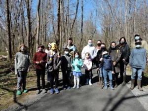
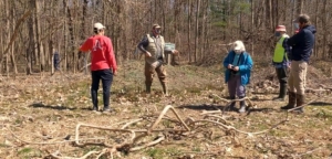
The ‘cast’ of characters for filming at Eakin Park – Photo: Sarah Glassco
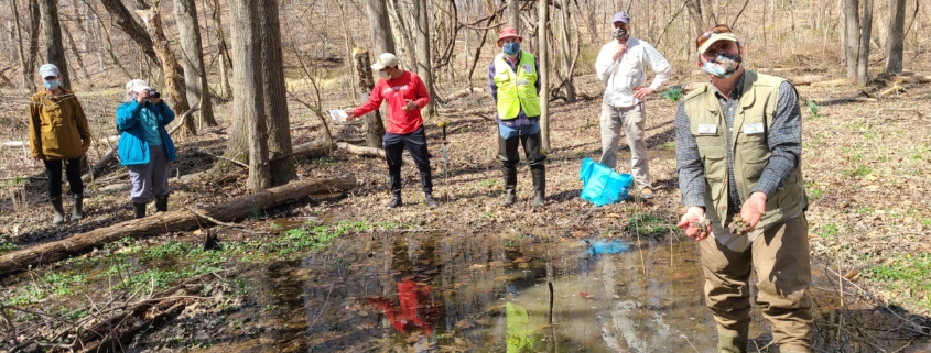
Friends of Accotink Creek are committed to protecting, promoting and restoring the water quality, natural habitat, and ecological well-being of the Accotink Creek watershed. To that end, back in spring 2021, spurred on by a grant from Virginia Lakes and Watersheds Association, FACC put out a call for FMN volunteers to help film on a weekend when FACC was to bring in Mike Hayslett to consult on a potential restoration of a vernal pool and evaluate some existing pools in Fairfax County. Three FMNs responded with a willingness to film: Sarah Glassco, Ashley Zywusko (now in Central Rappahannock chapter), and Kathryn Pasternak. At the time, Ashley and Kathryn were in their FMN training class, so this would be their first volunteer project. By the time production began FMNs Kim Schauer, Ana Ka’ahanui, and Tammy Schwab, along with additional FACC people, were involved and they would all make major contributions to the project.
Mike at a Nottaway pool – Photo: Sarah Glassco
In addition to the consultations, FACC objectives were to make a couple of videos for Fairfax County Elementary Schools. To make these films more compelling to kids they gathered some parents and their children to accompany Mike at Eakin Park. The organized ‘cast’ included a girl scout troop and some other interested youth. The first day Mike toured various wetlands in Fairfax County with the FMN/FACC team and Fairfax County Park Authority (FCPA) officials Tammy Schwab – Manager Education and Outreach, John Burke – Natural Resources Branch Manager, and Dan Grulke – Manager of Lake Accotink Park. Sarah, Ashley, and Kathryn filmed the events over Mike’s three-day visit, including an extensive interview at Eakin Park. Sarah provided subject matter for filming and provided help transcribing the interview. At the end of the weekend Kathryn collected all film footage, notes, and field data, proceeded to her studio and went into production mode. Future spin-off films will target elementary school level audience and will be distributed accordingly.
Mike Hayslett – Photo: Sarah Glassco
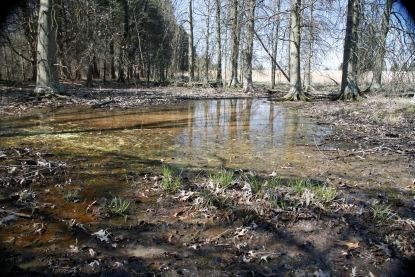
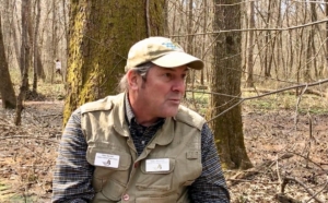
So why vernal ponds? Vernal ponds are so called because they are often, though not necessarily, at their maximum depth in the spring due to snow melt and heavier seasonal rains. Vernal meaning – ‘of, relating to, or occurring in the spring’. There are many local names for such ponds, depending upon where in the country they occur – sinks, wallows, kettles. But one term most people have not typically attached to them is ‘important’ – enter Mike Hayslett, Principal of Virginia Vernal Pools, LLC. The problem, Hayslett has said, is that many people view the pools as soggy nuisances, “so there’s a real disparity in the public’s understanding of their biological significance.”
Mr. Hayslett is a former biology and environmental instructor at Sweet Briar College and other Virginia schools, plus a member of the Allegheny Highlands chapter of VMN. He has spent his career pursuing the study, awareness, and conservation of freshwater wetlands known as vernal pools in and around his native Virginia. The film clearly illuminates Mike’s passion for vernal pools … his raison d’etre.
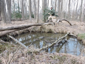
Evaluating area for restoration at Lake Accotink – Photo: Tammy Schwab
Because of his in-depth expertise, Friends of Accotink Creek (FACC) asked him to consult on one site identified for potential restoration at Lake Accotink. Accotink Creek watershed runs 25 miles through one of the finest wildlife corridors in Fairfax County. The creek meanders through the county parks of Eakin, Americana, Wakefield, Lake Accotink, and Accotink Stream Valley. It continues south through Ft. Belvoir and the Accotink Bay Wildlife Refuge, converges with the waters of Pohick Bay (which is fed by the Pohick Creek watershed), and drains into the Potomac River as the mouth of Gunston Cove, therefore contributing to the water that constitutes the Chesapeake Bay.
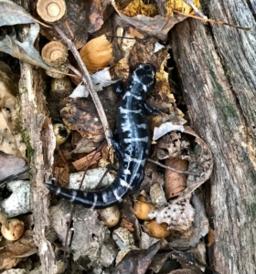
Marbled Salamander in search of a vernal pool – Photo: Jerry Nissley
Kathryn Pasternak became an FMN in 2021 but she is also a veteran of wildlife, conservation, and cultural films and recipient of two National Emmy Awards for ‘Best Science and Nature Program’. She spent 15+ years at National Geographic Television working on high-end television programs for international distribution. Since 2007, she’s been producing media independently both as a freelancer and small business owner. Therefore, she was adequately prepared to do the additional research into the lifecycle of vernal pools and to get additional film footage over the next two vernal mating seasons required to complete a visually compelling and scientifically accurate story. Through the collective efforts of the FMN ‘film crew’ and the FACC ‘production contributors’, FCPA officials, and an enthralled ‘cast’, Kathryn (Pasternak Media) produced an exemplary product that illustrates the value of educating the public on the vital ecological benefits of vernal ponds.
For example, vernal ponds favor native species because many non-native species cannot tolerate the extreme seasonal changes in environmental conditions for the local area in which the pond exists. With an inevitable end and an unstoppable beginning, these ephemeral oases may not look like much, but they shelter many imperiled species and play a pivotal role in the ecologically networked-webs of many forests and open depression wetlands.
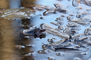
Wood frogs mating – Photo: Kathryn Pasternak
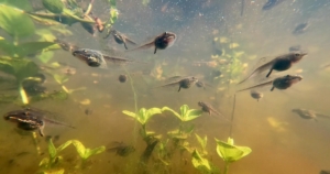
Wood frog tadpoles – Photo: Kathryn Pasternak
Despite being dry at times, vernal pools teem with life when filled, serving as critical breeding grounds for many amphibian and invertebrate species. The most obvious inhabitants are various species of breeding frogs and toads. Some salamanders also utilize vernal pools for reproduction, but the adults may visit the pool only briefly. Other highly specialized inhabitants are daphnia and fairy shrimp. The latter are often used as an indicator species to decisively define a vernal pool. Other indicator species, at least in parts of NoVA, are the wood frog, the spade foot toad, and a few species of mole salamanders (spotted, tiger, and marbled). The tiny Pea Clams discovered in one pool were thought to be a first encounter in Fairfax County and
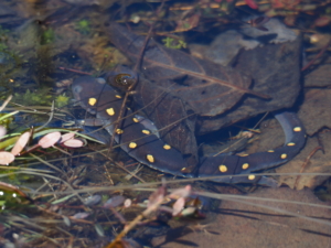
Spotted salamander – Photo: Krista Melville
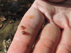
Pea clams – Photo: Sarah Glassco
evidence was sent to a lab in Ontario, Canada for verification.
To me, one of the most fascinating single phenomena of vernal pools is simply the explosive appearance of life in the just recently thawed waters of an emergent spring pool.
The film elicited a foundational precept instilled in me during my FMN-101 training that is worth repeating, ‘an awareness of nature (or a thing of nature) leads to understanding; understanding leads to appreciation; appreciation leads to caring; and caring leads to conservation’.
Without further ado, and just in time for the 2023 vernal pool season, here is their film journey through some vernal pools of Fairfax County – Fairfax Vernal Pools with Mike Hayslett