Clifton Institute 6712 Blantyre Road, Warrenton, VA
Saturday, October 23, 2021 9 am – 12:30 pm
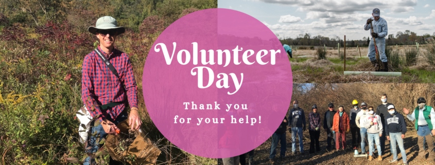
Invasive plant species crowd out native plants and provide little to no food for native animals. Every winter Clifton Institute works to remove invasive Autumn Olive from around their property and over the last few years they have made a lot of progress, thanks to all of their amazing volunteers! Join them on October 23 to start the 2021-2022 Autumn Olive removal season.
In the spring Clifton Institute planted 975 tree seedlings along the stream in their native grassland. They need your help finishing the planting with a few more trees.
https://fairfaxmasternaturalists.org/wp-content/uploads/2021/10/volunteer-day-2.5-845x321-2.png321845Janet Quinnhttps://fairfaxmasternaturalists.org/wp-content/uploads/2023/08/VMN-Fairfax-cmyk_w223h156.jpgJanet Quinn2021-10-09 19:06:292021-10-09 19:06:29Clifton Institute Work Days, October 23rd & 30th
As we celebrate Birdability Week, October 18 – October 24, 2021, we would like to highlight Steve Tzikas, an energetic volunteer who has been mapping trails in Northern Virginia for their “Birdability.”
“The Birdability Map is a crowdsourced map which describes the accessibility features of birding locations all over the world. This allows people with accessibility challenges to find out in advance if a birding location is one they would like to visit.”
Read Steve’s account of his mapping experience:
In early 2021 I inquired if the Audubon Society of Northern Virginia needed any volunteers for a citizen science field project that involved exercise. As I got older I needed more exercise opportunities, but as a scientist and engineer, I wanted it to involve science to keep my interest. The response I received informed me about Birdability, which was founded in 2016 by Virginia Rose. As the Birdability website notes,
“Birdability works to ensure the birding community and the outdoors are welcoming, inclusive, safe and accessible for everybody.” They “focus on people with mobility challenges, blindness or low vision, chronic illness, intellectual or developmental disabilities, mental illness, and those who are neurodivergent, deaf or hard of hearing or who have other health concerns.”
A lot of information can already be found on the Internet about Birdability, including that found on its own website. Rather than repeat much which has already been noted by others, this article focuses on how a government regulation can become common knowledge to the public.
Accessibility is an important part of trail development, because it is key to ensuring that trails are available to all groups such as the elderly and people with disabilities. The first accessibility laws were enacted in 1968 under the Architectural Barriers Act (ABA) of 1968. The Americans with Disabilities Act (ADA) of 1990 prohibited discrimination based on disability.
After some thought the proposal to volunteer and evaluate trails for Birdability became an interesting prospect, even if not citizen science. Birdability still offered exercise by walking trails, but it also intrigued me. One of my many duties as an engineer over the years was the creation and review of facility design standards and agency policies as they related to specific requirements for the environment, safety, health, and security. These were technical requirements that few people, except professionals, ever see. Such regulations keep the public safe, even if they are not aware of their surroundings and the issues that impact them. Sometimes, during reviews, a rather broad-based standard could include many other requirements not necessarily for my attention, but for other professionals in collaborating offices. As such, I would see information pertaining to ADA requirements.
So, when I reviewed the Birdability template used in trail reviews, I thought about how this organization took a complicated regulation and converted it to an app for the public to use, educating them in the process. Moreover, this caught my interest, because as an engineer I also develop models that track government operations based on transactional data and the resource requirements that are part of those operations. Developing models based on big data is another item only professionals will do. But, Birdability developed a public app based on “dry” government requirements and made it appealing, useful, and educational.
The Birdability survey template covers the basic ADA requirements so people with accessibility challenges can access a reviewed trail quickly and get outside to experience the natural surroundings. When submitting a survey, reviewers are asked to comment on ADA aspects including parking, ramps, restrooms, and other accessible features as well as trail accessibility criteria such as surface(s), slope(s), shade, benches, gates, railings, steps, and viewing blinds.
The largest section is for any additional information. This connects the trail to the types of birds seen, seasonal conditions, width of trails, overall difficulty, wildlife activity, and so on. This is followed by a section for rating the location’s overall accessibility, and there is the ability to add photographs.
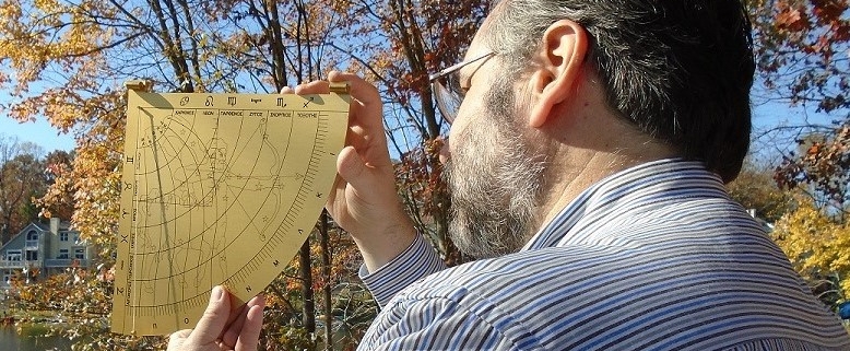
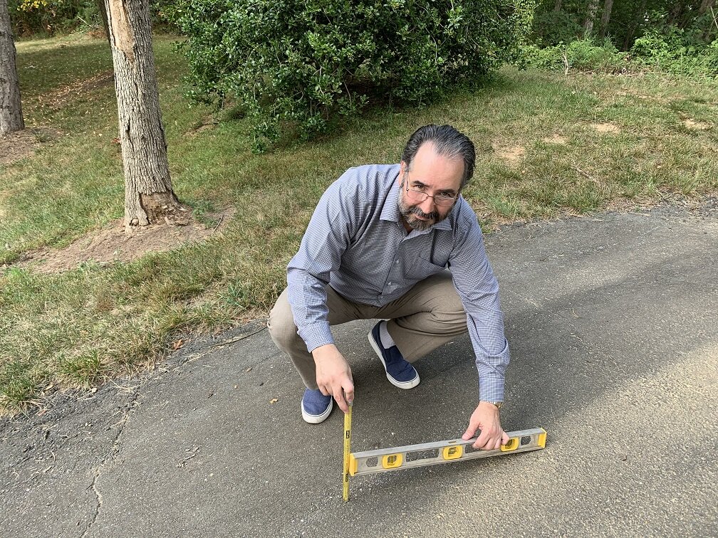
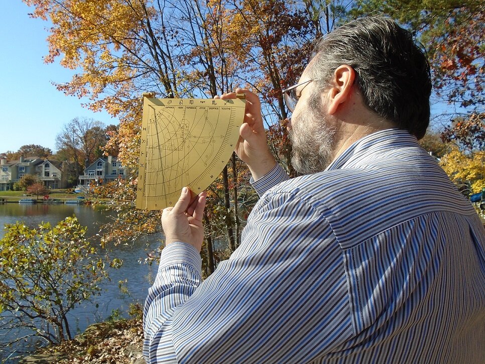
I forwarded suggestions for improvements, whether for future upgrades of the website itself, or to fellow reviewers on best practices for entering a review. For example; slope criteria are noted, but it’s not always an easy task to measure, especially if a trail has a lot of vertical variability. Reviewers can’t be expected to conduct an engineer’s transit measurement on every trail slope encountered. At first I attempted to measure the slope with the greatest incline. I used a simple astrolabe I owned to get a quick estimate for the degrees of inclination. However, it was even easier to take a photograph and post it so a reader could decide whether such inclines posed a challenge to their body strength or wheelchair. The photograph section of the survey template acted as a useful place to add information that words alone could not describe accurately. I also noted other ideas by including comments, such as whether a trail is accessible through public transportation.
Steve measuring slope
While most people might associate ADA with people using wheel chairs, the ADA also covers conditions due to deafness, blindness, diabetes, cancer, epilepsy, intellectual disabilities, missing limbs, autism, and other medical conditions.
The accessibility guidelines apply to those trails that are designed and constructed for pedestrian use. These guidelines are not applicable to trails primarily designed and constructed for recreational use by equestrians, mountain bicyclists, snowmobile users, or off-highway vehicle users. Regulations also recognize the existence of constraints and limitations in the outdoor environment and allow for certain other exceptions.
I do many of my reviews in my town of Reston, Virginia. Reston was founded in 1964 as a planned community. Today it has 60,000 residents, over 55 miles of walking paths, about 250 acres of woodlands and open space, 4 lakes, and a tree canopy covering about half of its total area. There is a high degree of accessibility, and there are many birds along the paths and lakes. Birdability offers the chance to get to know your community and what it has to offer. The Birdability map notes the locations where people have submitted reviews. It is constantly growing with submissions.
Steve with Astrolabe
If you are seeking a good experience with exercise and learning, Birdability mapping may be the one for you. Visit the website and view the Birdability map, where you can read what others wrote, as well as submit your own trail review. Whether it is a simple trail review, or a more thoughtful one that attempts to identify the variety of birds and their habits through the seasons, it’s worth a try.
https://fairfaxmasternaturalists.org/wp-content/uploads/2021/10/Bird_ADA_Tzakis-3.jpg543778Mary Ann Bushhttps://fairfaxmasternaturalists.org/wp-content/uploads/2023/08/VMN-Fairfax-cmyk_w223h156.jpgMary Ann Bush2021-10-07 18:49:552021-10-07 18:49:56New App Brings Awareness of ADA Requirements to Trails
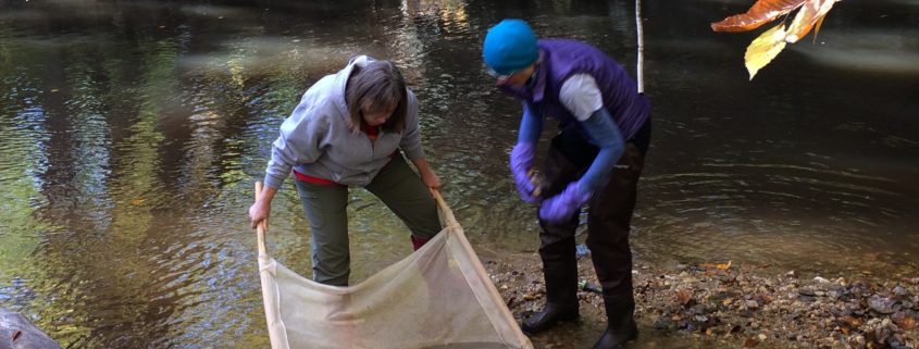
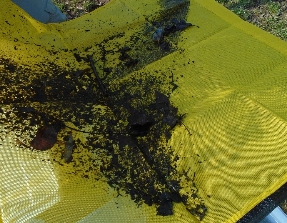
Upon following an approved sampling protocol, a net is ready for examination, collection, and identification of the macroinvertebrates captured on it.
As kids, we all had a fascination with bugs. If we owned a microscope, inevitably a few bugs would be examined close-up. We would be fascinated by the insects at natural history museums, even as an adult. Some of us would decide to make a career around bugs. With a vocational education leading to certification and licensing, one can become a pesticide applicator to protect homes and properties against harmful insects. With a little more education one can get a 4-year entomology BS degree. Personally I went into engineering, but it would not be the last time I encountered insects in some other than ordinary fashion. When I was Chief of the US Army’s Environmental Office in Japan, I had a program to control pine beetles on forested property overseen by the Army. There too were those pesticide applicators and any issues that I may have had to address with environmental and safety concerns. At another point in my career, with Ports-of-Entry programs, I was one of many who occasionally offered support to ensure our Agricultural Specialists had the resources they needed to secure America from deadly pests that could enter the country. In fact, there are many opportunities for aspiring students when it comes to insects. For those aspiring students, and for that matter curious adults, there are opportunities to get up close to insects, but in a more friendly manner, because these insects help us monitor the health of streams.
I just entered the Fairfax Chapter of the Virginia Master Naturalist (VMN) course program, and one of the classes covers entomology and invertebrates. The VMN program is a great way to offer community service, get some exercise, and learn something that might be beneficial for a future goal. When I retire I would like to take some graduate level courses in GMU’s environmental science program, which has a biology/ecology component.
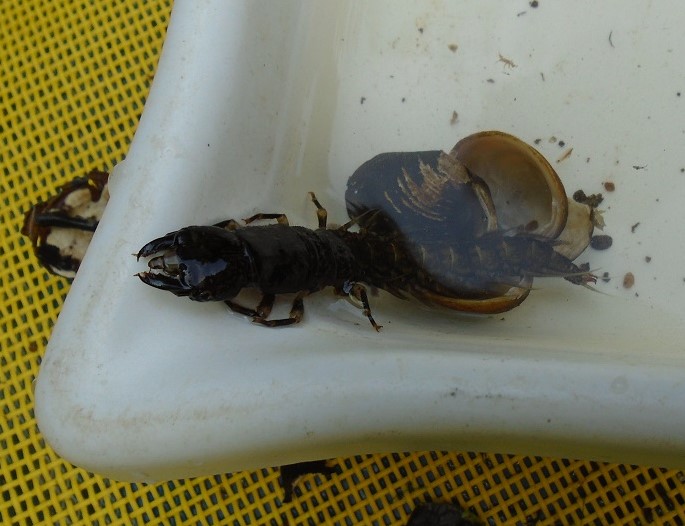
A large Hellgramite found by one of the sampling teams.
One of those local volunteer opportunities is with the popular stream monitoring program managed by the Northern Virginia Soil and Conservation District. It’s a chance to learn about watersheds, the basics of stream ecology and monitoring, the sampling and identifying of benthic macroinvertebrates, and the recording of that data for use by researchers and professional decision makers. For more information about this program, visit https://www.fairfaxcounty.gov/soil-water-conservation/volunteer-stream-monitoring.
This biological stream monitoring is great fun. People of all ages attend, not just teenagers. Like myself, there are also a lot of professionals – university graduates seeking new experiences, retired professors, and others who have an interest in life-long learning. Why not discover a whole new world of bugs? I hope to see you at one of the streams monitored in Fairfax County.
https://fairfaxmasternaturalists.org/wp-content/uploads/2018/11/IMG_6312.jpg24483264Janet Quinnhttps://fairfaxmasternaturalists.org/wp-content/uploads/2023/08/VMN-Fairfax-cmyk_w223h156.jpgJanet Quinn2021-10-07 11:25:272021-10-09 11:32:26A World of Bugs
By FMN C.E. Hike Coordinator Barbara J. Saffir (iNat username: DMVphotographer)
WHY USE INATURALIST?
If you want to contribute to citizen-science while exploring outdoors, iNaturalist’s free, user-friendly app and website provides the best virtual toolbox. Your data will actually get used. Real humans are available to respond to problems. You can join projects and interact directly with other observers around the globe. Plus, it’s downright fun! And iNat is powered by a world-class team of experts at the National Geographic and the California Academy of Sciences.
But before you start snapping pictures, learn how to improve your photos so your observations can be identified easier by iNat’s artificial intelligence, which, in turn, helps scientists more. Some helpful camera tips follow. But in some cases, it also helps to learn when you need to photograph specific parts of some critters or plants to identify them.
CAMERA
Whether you use a cell phone camera, a DSLR, a mirrorless, or a point-and-shoot, its best to learn your camera’s capabilities by practicing and by studying its manual.
APP OR WEBSITE?
Most of the time I photograph and upload directly from iNaturalist’s app because it’s faster, easier, and it’s the sole photo app I allow to use my location, due to privacy. Also, if I have cell service, I can identify observations in the field and upload them immediately — though I usually wait until I’m connected to a power source since those functions use a lot of “juice.”
However, instead of relying solely on unaltered photos uploaded directly from the app’s camera, your photos will be better if you tweak them first with a third-party processing program like Photoshop. In less than 60 seconds, you can often improve the composition (via cropping), lighting, sharpness, and more before uploading them to iNat. If you upload using your computer, you can batch-edit the dates and locations. The website is also better at identifying critters and plants because it gives you ranges and can confirm if observations of your organism have already been made in that county, adds a local science teacher who identifies thousands of iNat observations. She also recommends that you should only identify what you, yourself, can confirm. For example, she says if iNat suggests a “two-spotted bumble bee” but you’re only sure it’s a “bumble bee,” stick with that. Of course, beginners and/or casual users have to rely on iNat’s suggestions until they learn more.
BASICS FOR IMPROVING PHOTOS:
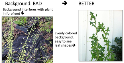
1. IN FOCUS:Look at your photo right away and if it’s not in focus, take another until it’s sharp.
2. SUBJECT SHOULD TAKE UP MOST OF THE FRAME:Get as close as feasible. Crop your photos to cut out major distractions, such as other species, weeds, and sticks. Don’t crop too much or it will result in poor resolution. Also, don’t waste your time using “digital zoom” on a camera because of its poor quality — unless you’re far away and you spot the Loch Ness Monster or Brad Pitt.
3. WELL-LIGHTED: Keep the sun behind you. Use flash or a flashlight if needed.
4.ADDITIONAL VIEWS MAY BE NEEDED FOR ID: Sometimes a close-up detail of an organism’s features, such as its underside, bark, leaves, head, etc., is needed. (See below for iNat’s ID tips.)
5.ADD SCALE IF NECESSARY: Use your finger, a ruler, a penny, etc.
6.NOTES: You can add notes to your observations, such as the number of plants or critters observed. You can also add that you shot a video if anyone wants to see it.
7.MISCELLANEOUS: Clean your lens before photographing. Check your battery. Use your foot, your chest, a tree, a fence, or another solid object as a makeshift tripod to prevent the camera from shaking. For plant photos, bring a piece of cardboard for a backdrop and to block the wind. Join iNat projects to share your finds with people who care about them most. Join local bioblitzes, such as City Nature Challenge each spring and Fairfax County Park Authority’s occasional bioblitzes.
INATURALIST’S PHOTO TIPS:To pinpoint certain species, such as mushrooms, flowers, turtles, snakes, and birds, it’s best to learn about those subjects independently to know what kind of details are required to clinch an ID of specific species. For example, with birds, it helps to photograph the entire bird, and to document important details, such as its color, shape, size, beak, behavior, habitat, and feather field marks (such as an eye ring or bars on its feathers) with photo(s) or in notes. https://www.inaturalist.org/guides/2465
Lena Struwe and Peter Nitzsche, Rutgers University
DISCOVERY TIME: So now that you’re prepared to contribute better photos to help citizen-science, the only question is: “Where should I go hunting for nature today?” You don’t even have to venture far from home. Fairfax County has more than 400 parks along nearly 1,000 miles of paved and dirt trails. Maybe you’ll even discover a whole new species. This year, Virginia Tech discovered a new species of millipedes on its own campus.
https://fairfaxmasternaturalists.org/wp-content/uploads/2021/10/Barbara.jpeg9071375Janet Quinnhttps://fairfaxmasternaturalists.org/wp-content/uploads/2023/08/VMN-Fairfax-cmyk_w223h156.jpgJanet Quinn2021-10-06 17:12:482021-10-06 17:12:48How to Improve Your iNaturalist Photos to Better Help Scientists
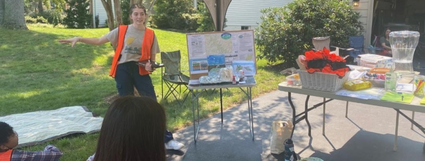
Article by FMN & Gold Award Girl Scout Mackenzie Nordai Photos courtesy of Mackenzie Nordai
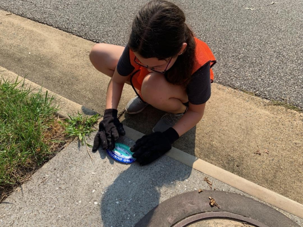
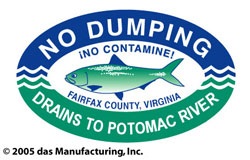
My Gold Award* aimed to address the issue of nonpoint source pollution’s effect on Pohick Creek Watershed which includes Hidden Pond Park in Springfield, Virginia. As the leader of the project, I led groups of volunteers through three communities adjacent to this watershed and labeled stormwater drains to alert people about where these drains lead. I also communicated awareness to the communities around Hidden Pond through a community newsletter, Fairfax Master Naturalist social media, and postings on bulletin boards at Hidden Pond Nature Center about the negative effects that nonpoint source pollution has on the environment. Nonpoint source pollution has the largest impact on our water quality, because it comes from many sources like our suburban neighborhoods. Some examples include fertilizers, pesticides, dog waste, car soap, oil, grease, antifreeze, paints, sediment, and excess salt from salting the roads. When it rains, the runoff from our neighborhoods enter our stormwater drains dispersing different pollutants into our ponds, lakes, streams, and rivers leading to the Chesapeake Bay and eventually into the Atlantic Ocean, which can hurt the ecosystem and marine life.
Did you know that a single six pack plastic ring can last 400 years before it finally can decompose? And paints, oils, and grease can pollute the waters through dissipation. These pollutants along with various others can impact different wildlife through suffocation and by changing the environment’s carrying capacity to a level that the wildlife can no longer sustain. Amphibians, for example, have thinner skin than most animals and are affected by water and air pollutants, so imagine what a drop of oil or grease is going to do to a whole population of organisms.
I selected my issue, because I care about the environment, plan to pursue a related field in college, and have already begun educating others on this topic during my coursework to become a certified Fairfax Master Naturalist. While doing so I was inspired to spread the knowledge about how to prevent nonpoint source pollution and the impacts that it has on our watersheds. As I delved into research, I felt a passion in understanding the impacts of pollution and I felt driven about educating others on what society can do to help prevent it.
In conclusion, there are ways that we all can help our environment by preventing nonpoint source pollution. First, you can contact the Northern Virginia Soil and Water Conservation District (NVSWCD) and label the stormwater drains in your neighborhood to increase awareness. Next, you could work on establishing native plants in your landscaping and minimize fertilizers and pesticides, or by purchasing household detergents and cleaners that are low in phosphorus. Also, you can dispose of used oil, antifreeze, paints and other household chemicals properly. Lastly, you can properly dispose of dog waste and litter. All of these actions help to protect the environment and our local watershed.
* The Girl Scout Gold Award is the highest award a Girl Scout Senior or Ambassador can earn. A Gold Award Take Action Project has national and/or global links, is sustainable, takes approximately 80 hours and addresses an issue the Girl Scout cares about.
https://fairfaxmasternaturalists.org/wp-content/uploads/2021/10/Presentation.jpeg8091080Janet Quinnhttps://fairfaxmasternaturalists.org/wp-content/uploads/2023/08/VMN-Fairfax-cmyk_w223h156.jpgJanet Quinn2021-10-05 21:37:252021-10-05 21:37:26Nonpoint Source Pollution & Labeling Stormwater Drains, a Gold Award Project